Two 'super typhoons' are active offshore the Pacific
Two very strong storms, Typhoon Sepat and Typhoon Flossie , are operating offshore the Pacific.
Sepat storms in the past 24 hours have increased to 3 levels and become super storms. At 16:00 on August 14, the location of the center of storm Sepat is about 16.1 degrees north latitude, 130.6 degrees east longitude, about 800km east of Luzon Island (Philippines). The strongest wind in the area near the storm center is 13-14 (ie from 134 to 166 km / h), jerking to level 15-16.
It is expected that in the next 24 hours, Typhoon Sepat will move mainly in the West, about 10km per hour for every hour and further increase. After that, the storm has the ability to slow down and change to the North-West and North-West. On August 19, Typhoon Sepat will be able to cross Taiwan island into the waters between Fujian and Taiwan.

The direction of storm Sepat (Photo: tsr.mssl.ucl.ac.uk)
Flossie storm is active in the eastern hemisphere. At 16:00 on August 14, the position of the center of the storm is about 16.2 degrees north latitude, 152.7 degrees west of the west, the strongest wind level is 14-15 (that is, from 150 to 183 km / hour), jerking over level 16.
In the next 2 - 3 days, this storm moves in the direction of West - Northwest and Northwest, about 15km per hour and there is also a strong possibility. However, Typhoon Flossie is less likely to move to the Eastern Hemisphere but will weaken and fade away as it approaches the meridian of 175 degrees west.
About the possibility of impact between two storms, because they are nearly 70 long distances from each other (about 8,000km), the interaction will be negligible.
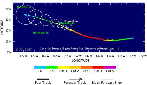
The direction of the storm Flossie
- The worst natural disaster is still ahead
- The idea of beating super typhoons with US nuclear bombs
- The trio of super typhoons are raging on the Atlantic
- Can 2015 El Nino cause more natural disasters?
- Scary phenomena can occur in super typhoons
- Why did Mangkhut become a super typhoon in the Pacific?
- The most intense super typhoons in the history of the Atlantic
- Discovering super-active galaxies in the early universe
- Offshore wind power: Potential in the future
- Plankton contribute to super typhoons
- A strong storm of level 14 appeared in the South China Sea
- Hanoi plans to respond to super typhoon Mangkhut
 Is the magnetic North Pole shift dangerous to humanity?
 Washington legalizes the recycling of human bodies into fertilizer
 Lightning stone - the mysterious guest
 Stunned by the mysterious sunset, strange appearance