Using radar to sweep through the ground, discover an ancient Roman city
Scientists have announced the discovery of an ancient city in the northern capital of Rome (Italy) by ground-sweeping radar (GPR).
The magnificence of the long-buried city of Falerii Novi in the Tiber River valley area has been "exposed" without having to flip any bricks. Instead, a team of scientists at Cambridge University (UK) and Ghent University (Belgium) have used GPR devices and satellite navigation systems to create 3D simulation images. ) of the old missing city.

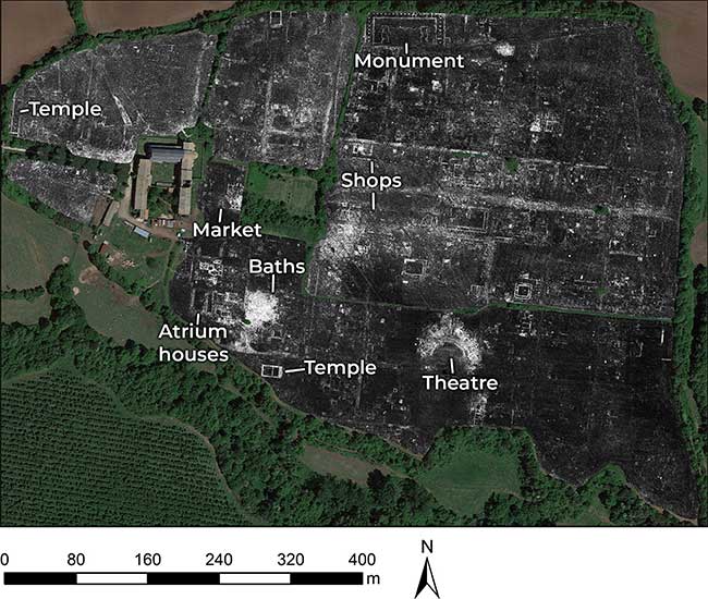
Image of the ancient city of Falerii Novi in the northern capital of Rome, Italy is obtained using radar scanning through the ground (GPR). (Photo courtesy of University of Cambridge (UK) June 4, 2020: AFP / TTXVN)
Traditional excavation methods and two-dimensional (2D) imaging techniques, such as using magnetometers, have revealed many clues about the shape of ancient Roman citadels but cannot provide an overview of the formation. into these cities. The GPR can even help researchers map more and more ancient cities without having to excavate areas or influence architectural structures built on them.
The results published in the journal Antiquity on June 9 evoked many aspects of Roman architecture and urban design that were less well known.

The city is thought to have formed in 241 BC. (Photo courtesy of University of Cambridge (UK) June 4, 2020: AFP / TTXVN)
Professor Martin Millett, one of the authors of the study, said this was the first time the GPR was used to create a complete city map. The device helps create a high-resolution panorama of things hidden on the ground, even allowing people to see what is happening at different depths.
The city of Falerii Novi - appearing from modern Roman times - has been buried underground for about 13 centuries. With an area of about 250.000m 2 , the city is said to be formed in the year 241 BC and inhabited until the early Middle Ages, around the year 700 AD.
The 3D images the team collected show the appearance of temples, public buildings, as well as a cylindrical walkway thought to be a public building.
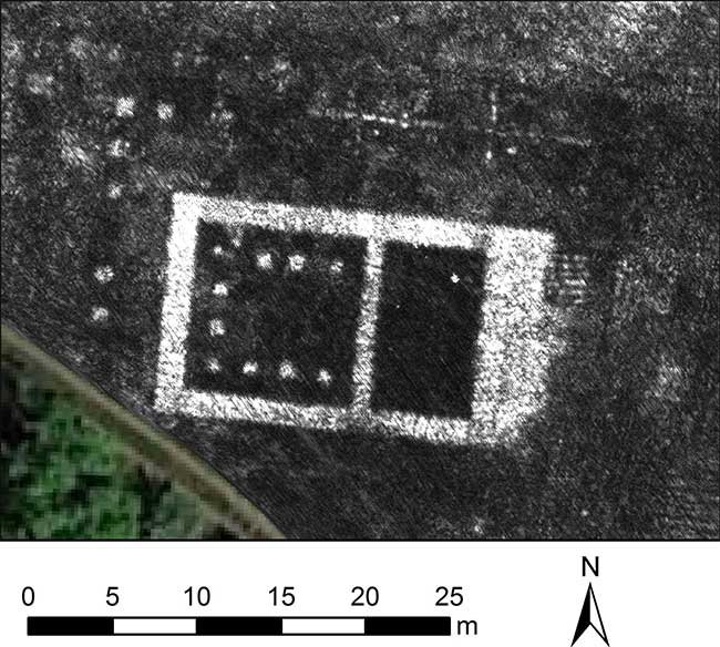
The city also has a route that almost surrounds the suburbs, focusing on religious buildings. On this street is a special building, up to 60 m long with huge columns, inside containing 2 smaller buildings with niches decorated with statues and . fountains.
The most amazing is the modern water supply and drainage system built by the third century people. Scientists have found a large building that can take on the role of a water plant with pipes and sewers connecting from here to across the city. This helps residents enjoy public baths and a comfortable swimming pool.
The city of momentum existed for nearly 5 centuries before being destroyed around 700 AD.

Image of Falerii Novi city with ground-based radar technology. (Photo: Guardian).
The authors emphasize that although smaller than the neighboring capital of Rome, Falerii Novi's plan is designed "more elaborately than any other small city".
In the meantime, scientists will carefully analyze the images related to Falerii Novi to better understand this ancient city and the process of analyzing the collected data may take a few moments. month.
- Discover an entire ancient Roman cemetery under the parking lot
- Discovering the old city with a 2,000-year-old penile image?
- The city of ancient super-rich Romans sank under the sea
- Roman city 2,000 years under construction site
- Roman villa nearly intact after 1,000 years under the park
- Discover the 'whole vegetable' diet of ancient Roman gladiators
- Discover the remains of an ancient city on the outskirts of Vienne
- Reveal new findings in ancient Roman city - Pompeii
- Discovered an ancient arrow 2,000 years ago of the Romans in Israel
- Huge pool in ancient Roman city
- 2,000-year-old city trace in Egypt
- Discover the ancient Roman military road
 Discovered an ancient centipede fossil 99 million years old
 Discovered bat-like dinosaurs in China
 Discovered a 200-year-old bronze cannon of the coast
 Discover 305 million-year-old spider fossils