Utor storm tomorrow causes strong winds of 100km / h in the Gulf of Tonkin
In the East Sea, super typhoon Utor continued to grow, reaching nearly 170km / h (level 14). The storm with an area of hundreds of kilometers of influence caused the Gulf of Tonkin to suffer from dangerous winds from tomorrow, August 14.
The hydro-meteorological forecasting center said that this morning, Utor storm center was about 360 km east of the northeast of the Hoang Sa archipelago, the wind speed near the center reached level 14 (maximum 166km / h). With the power of a super typhoon, there are times when strong winds add 3 levels, reaching over 210km / h.

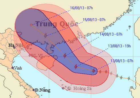
Compared to yesterday, the storm moved more toward the west, instead of going north.Therefore, the probability of a storm impact on northern Vietnam has increased.(Photo: NCHMF)
Compared to yesterday's forecast, the typhoon has a more moving direction toward the west, which means more likely to affect Vietnam.
The meteorological agency, day and night, storms in the direction of west-west and west-west, then changes in the northwest with a speed of 15-20km / h and can be stronger. On the morning of August 14, the center of the storm was about 100km east of Hainan Island (China), one level higher than the east northeast. The storm was then expected to enter the Guangxi province (China) and was located in the province on August 15.
Super typhoon is causing strong winds of 100km / h to over 170km / h (level 11 to 15) throughout the North China Sea. Particularly in Hoang Sa northeast, strong wind level 9, after rising to level 13 (approximately 150km / h). From tomorrow (August 14), northern Gulf of Tonkin (including the districts of Bach Long Vi, Co To, Van Don and Cat Hai) starts to have dangerous wind. The northern part of the wind bay alone can reach over 100km / h, the level of sinking fishing boats.

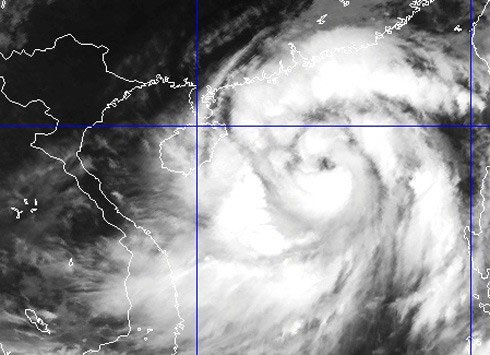
Super storm satellite image this morning.(Photo: NCHMF)
In response, on August 12, the Central Steering Committee for Flood and Storm Control and the Committee for Search and Rescue had the second transmission to provinces and cities in the North and coastal provinces from Thanh Hoa to Phu. Yen as well as related ministries and branches. The Ministry of Foreign Affairs sent a diplomatic note to the Chinese embassy in Hanoi, asking Chinese agencies to create favorable conditions for Vietnamese fishermen and ships and boats to shelter from storms and ashore when needed. set.
At the meeting on August 12, the Steering Committee for Flood and Storm Prevention and Control requested localities to respond to storms causing heavy rains in the northeast and northern mountainous areas.
As of this morning, border guards from Quang Ninh to Ca Mau informed, counted and instructed 73,354 vehicles with 315,262 people who knew about the storm. There are 952 vehicles with 8,842 people operating in the Spratly Islands.
- Storm No. 6 is heading north of the Gulf of Tonkin
- Hurricane Kalmaegi caused strong winds of level 12 at Bach Long Vi island
- Hurricane 6 suddenly turned, headed into the Gulf of Tonkin
- Storm No. 4 increased to level 11, entering the Gulf of Tonkin
- Jebi storm level up in the East Sea
- Typhoon Utor crossed Luzon Island, into the South China Sea
- Super hurricane Utor into China
- Prohibition of boats in the Gulf of Tonkin, coping with storm No. 3
- Utor storm will cause heavy rain in the northeast provinces
- Tonight, typhoon Son Tinh attacked, many places at risk of flooding
- Jebi stormed into the Gulf of Tonkin
- Influence of super typhoon, East Sea is about to have strong winds
 Is the magnetic North Pole shift dangerous to humanity?
 Washington legalizes the recycling of human bodies into fertilizer
 Lightning stone - the mysterious guest
 Stunned by the mysterious sunset, strange appearance