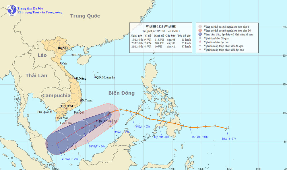
Washi storm raged on the South China Sea
At 04:00 on December 19, the location of the center of the storm was about 9.7 degrees Vi Bac; 113.9 degrees east longitude, about 250 km away from Truong Sa archipelago to the northeast of the northeast. The strongest wind in the area near the storm center is strong at level 8 (ie 62 to 74km per hour), level 9 and level 10 jerks.
It is forecasted that in the next 24 hours, the storm will move in the direction of West and West Southwest every hour, about 20-25 km. At 04:00 on December 20, the location of the storm center is about 7.4 degrees North; 109.4 degrees Kinh Dong, on the southwestern area of Truong Sa archipelago, about 330 km east of Con Dao to the Southeast. The strongest wind in the area near the storm center is strong at level 8 (ie 62 to 74km per hour), level 9 and level 10 jerks.

Location and path of the storm
In the next 24 to 48 hours, the storm moved in the direction between Western Southwest and Southwest, about 20km per hour and gradually weakened into tropical depression. This tropical low pressure area continues to go south and weaken into a low pressure area. At 04 hours on December 21, the central location of the low pressure area is about 4.7 degrees Vi Bac; 105.0 degrees east longitude, about 490 km south of Con Dao island. The strongest wind in the center of the low pressure area falls below level 6 (ie from less than 39km per hour).
Due to the influence of storm circulation in combination with cold air in the Middle and South Sea areas (including the Spratlys waters), there are strong winds of level 6, level 7, the area near the center of the storm passes through level 8 , level 9, level 10 jerks, showers and strong thunderstorms. Strong sea; During thunderstorms tornado precautions required. The waters off the Central Coast and the South, the North East Sea (including the Paracel Islands) have strong northeast winds of level 6, level 7, level 8 and level 9, strong seas.
- Philippines: Nearly 500 people were killed by typhoon Washi
- Washi headed for the Spratly Islands
- Filipinos are miserable after the storm
- Philippines devastated after a big storm
- Washi weakened into a tropical depression
- 50 people died of typhoons in the Philippines
- Flash floods in the Philippines: 650 deaths, 800 missing
- 1500 people killed by Typhoon Washi
- Hurricane number 11 advanced quickly into the South China Sea
- Storm No. 13 could change direction, targeting Central
- The number of deaths from typhoons in the Philippines exceeds 900
- Hurricane Kalmaegi accelerated, advancing rapidly into the South China Sea
 Is the magnetic North Pole shift dangerous to humanity?
 Washington legalizes the recycling of human bodies into fertilizer
 Lightning stone - the mysterious guest
 Stunned by the mysterious sunset, strange appearance