Storm No. 13 could change direction, targeting Central
In the early morning of November 10, Haikui storm entered the South China Sea and became the No. 13 storm in the South China Sea during the year. The direction of the storm's movement is complicated.
Storm center number 13 (international name Haikui - meaning anemone sea) 7 am this morning, about 860 km southeast of Hoang Sa archipelago with wind speed of level 8 (60-75km / h), level 10 jerk.
Day and night, the storm moves west-northwest with a speed of 20km / h and also has a stronger ability. Early in the morning, the storm center is about 400km east of the Hoang Sa archipelago to the southeast, the wind increases by one level.
Influence of storm circulation, the eastern sea in the north of the area and between the East Sea with heavy rain and thunderstorms, strong winds gradually rise to level 6-7, the area near the center of the storm passes through the level of 8-9, level 11 shock twelfth. Dangerous zone in the next 24 hours (strong wind level 6 or higher) from latitude 12 to 17 degrees north latitude; east of meridian 113.5 degrees east longitude.
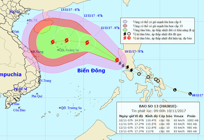
Predicting the direction of the storm is changing (photo above is the early morning newsletter).The meteorological agencies in the world yesterday said that the storms landed and Hainan Island (China) but this morning predicted to be able to break into Central Vietnam.(Photo: NCHMF).
The storm then changed direction to the west, slowing down but still continuing to increase. At 7:00 on November 12, the storm center in the northeastern part of Hoang Sa archipelago. The strongest wind is in the area near the center of strong storm level 9-10 (75-100km / h), level 13 jerks.
With the new direction, meteorological agencies identified that storms could directly affect the Central region.
- This morning, the storm started to cause rain in the Central region
- Why do storms often follow the West-North direction?
- Storm No. 13 is approaching the Paracel Islands
- Storm No. 4 changed direction and got stronger
- 'Strange' path of storm No. 4
- Lightning protection with laser
- Road to storm No. 4 changes, stormy center to the coast of Ha Tinh - Da Nang
- In the morning, Typhoon Podul landed in the Central Region
- Hurricane Podul, level 10, is heading into the South China Sea
- The storm with extraordinary speed is heading into the South China Sea
- Storm No. 12 weakens into a tropical depression
- Typhoon Gaemi will land in Central Vietnam
 Is the magnetic North Pole shift dangerous to humanity?
 Washington legalizes the recycling of human bodies into fertilizer
 Lightning stone - the mysterious guest
 Stunned by the mysterious sunset, strange appearance