Storm No. 4 changed direction and got stronger
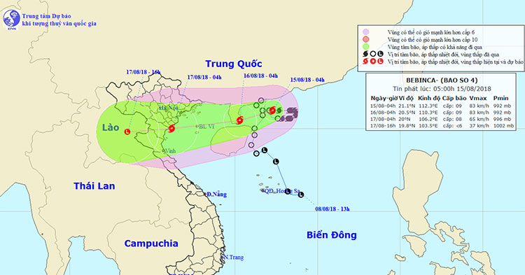
At 04:00 on August 15, the location of the center of the storm was about 21.1 degrees north latitude; 112.3 degrees Kinh Dong, on the southern coast of Guangdong province (China). The strongest wind in the area near the center of the storm is strong at level 8-9 (60-90km / hour), level 11 shock. Range of strong winds of level 6, shock level 8 about 100km from the center of the storm.
It is forecasted that in the next 24 hours , the storm will move west and southwest, about 10km per hour. At 04:00 on August 16, the location of the center of the storm is about 20.5 degrees north latitude; 110.3 degrees Kinh Dong, on the southern area of Leizhou Peninsula (China), about 350km from Hai Phong to the East. The strongest wind in the area near the center of the storm is strong at level 8-9 (60-90km / hour), level 11 shock. Range of strong winds of level 6, shock level 8 about 110km from the center of the storm.
Due to the impact of storms, the North East Sea region has strong winds of level 6; In the North-West of the North East Sea, there is a storm, strong winds of level 7, the area near the center of the storm passes through level 8, level 10. The sea is strong.
Location and movement direction of storm No. 4 .
Dangerous area in the East Sea in the next 24 hours (strong wind level 6 or higher): North of 19.5 degrees North latitude; east of meridians 108.5 degrees of east longitude.
In the next 24 to 48 hours , the storm moves west-southwest, about 15km per hour. At 04:00 on August 17, the location of the storm center is about 20.0 degrees North latitude; 106.2 degrees Kinh Dong, on the coast of Quang Ninh-Thanh Hoa provinces. The strongest wind in the area near the storm center is strong at level 8 (60-75km / hour), level 10 shock. The level 6 strong winds, level 8 jerks about 100km from the center of the storm.
In the next 48 to 60 hours , the storm moved west-southwest, each hour was 15-20km, went to the mainland of Hai Phong to Thanh Hoa and weakened into a tropical depression, then depressions Tropical continue to go deep inland and weakened into a low pressure area in Upper Laos area. The strongest wind in the center of the low pressure area falls below level 6 (below 40km / hour).
Level of disaster risk due to storm: level 3.
Heavy rain warning : From the night of August 15 to August 17 in the Northern provinces and North Central Vietnam, there will be heavy rain to great extent (rainfall of 250-350mm / batch).
In addition, due to the influence of the tropical convergence band combined with the southwest monsoon activity, so during the day and tonight (August 15), in the Middle and South Sea (including the archipelago waters) Truong Sa), waters from Binh Thuan to Ca Maut continue to have strong southwest wind level 6-7, shock level 9, high waves from 2-4m; strong sea.
The waters of the Gulf of Tonkin, the waters from Ca Mau to Kien Giang and the Gulf of Thailand have strong thunderstorms; in the thunderstorm there is the possibility of tornado and strong wind.
Level of disaster risk due to strong winds, big waves: level 1.
- Nakri is probably the strongest storm since the beginning of the year in the South China Sea
- Storm No. 12 is gradually stronger, heading straight to Khanh Hoa - Ninh Thuan
- Typhoon Mujigae is strong, winds are level 14, 15
- Jebi storm level up in the East Sea
- Why do storms often follow the West-North direction?
- 'Strange' path of storm No. 4
- Storm No. 13 could change direction, targeting Central
- 9-Usagi storm strengthened gradually, the wind jerked up to level 12
- Storm No. 7 constantly changed direction, the sea was very strong
- No.1 storm suddenly changed direction, can go through Hai Phong, Hanoi
- Linfa storm changed direction, could affect Vietnam
- Mujigae storms move faster and stronger
 Is the magnetic North Pole shift dangerous to humanity?
 Washington legalizes the recycling of human bodies into fertilizer
 Lightning stone - the mysterious guest
 Stunned by the mysterious sunset, strange appearance