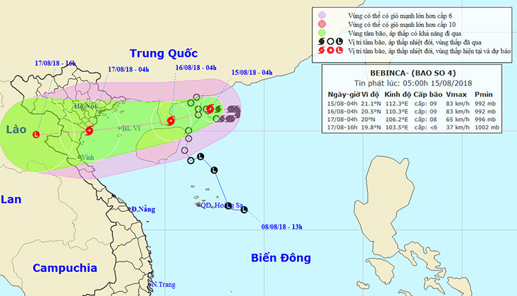
'Strange' path of storm No. 4
According to the Windy forecast page, the direction of the number 4 storm from the formation on the Tropical Depression is unpredictable, changing direction continuously.
Accordingly, in the model predicting the direction of the tropical depression then strengthened into the No. 4 storm of Windy site, there was also a different day by day.

Storm No. 4 has been an abnormal direction since the tropical depression.(Photo: National Center for Hydrometeorology).
However, in the model newsletters forecasting the following days, the direction of the storm No. 4 continuously changes.
On August 9, Typhoon No. 4 was on the northern side of Hainan Island (China), continuing to enter Guangdong Province (China), then running along the border of our northern mountainous provinces. .
But after officially becoming a storm No. 4 on August 13, the forecasting model showed that the storm has international name Bebinca move away, northeast of Hainan Island (China) and landfall adjacent to Guangdong province (China), then directed to the waters of Quang Ninh in our country.
The latest forecast model on August 14 also produced similar results, but when inland, the storm No. 4 weakened in the provinces from Quang Ninh to Nam Dinh.
Previously, a meteorological expert in Vietnam said that the Tropical Depression then strengthened to storm No. 4 will make forecasters have a headache when predicting the direction. The models themselves are also expected to change significantly from the previous forecast.
- Direct update of the path of Typhoon Mangkhut
- Storm Dianmu accelerated, Hanoi prepared to catch a storm
- Mujigae storms move faster and stronger
- Actively respond to storm Nari
- Typhoon Tembin lowered the level
- Typhoon Kalmaegi has entered the South China Sea, the country has scattered rain
- Hurricane 2 is shocking level 13-14 and continues to increase
- Storm Nari advanced quickly into the South China Sea
- Discovering the 'strange black shadow' in the midst of a storm in America
- Typhoon Wutip headed to Central
- Hurricane Kalmaegi moves at a very fast speed
- Strong tropical depression into a storm near the East Sea
 Is the magnetic North Pole shift dangerous to humanity?
 Washington legalizes the recycling of human bodies into fertilizer
 Lightning stone - the mysterious guest
 Stunned by the mysterious sunset, strange appearance