Typhoon Tembin lowered the level
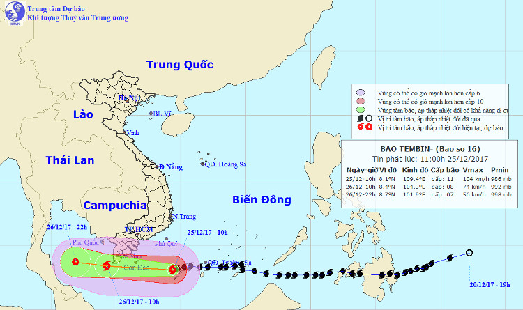
One level lower than when sweeping across Spratly and Huyen Tran islands last night, Typhoon Tembin tended to deviate to the south.
The newsletter of 25/12 of the Central Hydrometeorological Center said that Typhoon Tembin is decreasing in intensity compared to the strongest time in Truong Sa and Huyen Tran islands (135km / h).

Typhoon Tembin's direction follows the central hydro-meteorological center.
At 10 am, the storm is 290 km far from Con Dao (Ba Ria - Vung Tau) to the East, the strongest winds are 115km / h (level 11), two levels of recoil. Tonight, the storm weakens, the speed of travel is still 20km / h.
When entering the sea of Ca Mau - Kien Giang at 10 am on December 26, the storm has a wind speed of 75km / h (level 8), shocking three levels. Wind intensity remains the same when the storm hits the mainland of Soc Trang, Hau Giang, Bac Lieu and Ca Mau provinces.
The provinces of Tien Giang, Ben Tre, Tra Vinh, Vinh Long, Can Tho, Kien Giang and other areas of Nam Bo wind decreased by one level.
" The possibility of getting closer to the mainland, Typhoon Tembin continues to weaken. However, its level of risk is still at level 4 (serious) because there are few storms in the South and flat areas so the wind and rain are more raging." , representatives of the Central Center for Hydro-meteorological Forecasting recommend.
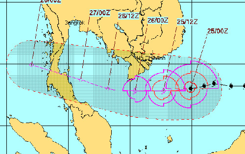
Similarly, international hydrometeorological agencies such as the US, Hong Kong, and Japan also expect Tembin storm to be downgraded and tend to deviate further south. The mind of the storm no longer landed directly in Ca Mau like the original.

Typhoon Tembin's path follows the US Navy forecast.
Currently, the provinces in the Southwest still have to deal with the storm with this complicated development. Hundreds of thousands of people in Soc Trang, Hau Giang, Bac Lieu, and Ca Mau . wandering furniture to evacuate to a safe place, some people refused to go and were coerced to a safe place before the landfall of Typhoon Tembin . Also in the morning, the delegation of the Central Government led by Deputy Prime Minister Trinh Dinh Dung was present in Soc Trang - one of the four provinces predicted by Typhoon Tembin will land to inspect and direct storm response. .
Previously, judging from the storm, Director of the Central Center for Meteorological and Hydrological Forecasting Hoang Duc Cuong said that this is the late storm season, late storm, an average of 10 years, but with a strong level like Typhoon Tembin is unprecedented.
The unusual feature of this storm is that the storm circulation deviates to the north and west of the storm center location. Therefore, the strongest rain and wind regions are concentrated in the north and west of the storm center.
It means that even if storms hit Ca Mau, strong wind areas still affect South Binh Thuan and Vung Tau."Even when the typhoon decreases the level when coming to Truong Sa and then ashore, the quick-breaking storm clouds also cause heavy rainfall of 150-200 mm from the night of 25 to the end of December 26," Mr. Cuong said.
Entering the East Sea and becoming the 16th storm in the night of December 23, Typhoon Tembin was considered a strong storm, capable of landfall with a 13-degree gusting wind.
- Tembin stormed up and landed in our country tonight
- Tembin storms into Ca Mau tonight
- Why say Typhoon Tembin is a catastrophic storm?
- Severe typhoon level 16 is about to enter the South China Sea
- Typhoon Tembin jumped 13, the North warmed
- Typhoon Tembin made landfall in South Korea causing much damage
- Typhoon Tembin swept over, the DK1 rig shook
- The sea was strong because of the influence of the circulation of storm Tembin
- Why did Typhoon Tembin kill so many people in the Philippines?
- Typhoon Tembin weakened into a tropical depression
- Emergency storm (Typhoon Haitang)
- Why is the storm No. 6 constantly growing, moving unpredictably?
 Is the magnetic North Pole shift dangerous to humanity?
 Washington legalizes the recycling of human bodies into fertilizer
 Lightning stone - the mysterious guest
 Stunned by the mysterious sunset, strange appearance