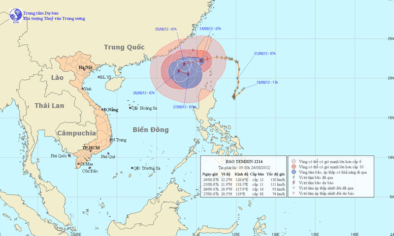
Severe typhoon level 16 is about to enter the South China Sea
At 7 o'clock on August 24, the location of the center of the storm was about 22.2 degrees Vi Bac; 120.6 degrees Kinh Dong, on the southern island of Taiwan (China). The strongest winds in the area near the center of the storm are strong at level 12, level 13 (ie from 118 to 149km per hour), level 14, level 15.
It is forecasted that in the next 24 hours, the storm will move in the direction of West and West Southwest, about 10km per hour. At 7 o'clock on August 25, the location of the storm center is about 21.8 degrees Vi Bac; 118.5 degrees Kinh Dong, about 880 km from Hoang Sa archipelago to the Northeast. The strongest winds in the area near the storm center are strong at level 10, level 11 (ie from 89 to 117km per hour), level 12 and level 13 jerks.

Beam photos of the path and location of the storm
In the next 24 to 48 hours, the storm moves in the southwest direction, about 5km per hour. At 7:00 on August 26, the location of the storm center is about 20.9 degrees North latitude; 117.8 Kinh Dong, about 770km from Hoang Sa archipelago to the Northeast. The strongest wind in the area near the storm center is strong at level 9, level 10 (ie from 75 to 102 km per hour), level 11 and level 12 jerks.
In the next 48 to 72 hours, the storm moved in the direction between East and Southeast, about 5km per hour.
Due to the influence of typhoon circulation, the North East Sea has strong winds of level 7, level 8, then increase to level 9, level 10, the area near the center of storm passes through level 11, level 12, level 13, level 14. The sea was fierce.
- Typhoon Yutu is level 16, entering the South China Sea tonight
- Haima storm causes level 16 wind to enter the South China Sea
- Super typhoon on level 17 is entering the South China Sea
- Vietnam may face new super typhoons
- Typhoon Linfa has entered the South China Sea
- The typhoon Nanmadol indirectly caused the male to rain a lot
- Why is the storm No. 6 constantly growing, moving unpredictably?
- Tropical depressions into the East Sea are likely to become strong storms
- Typhoon Doksuri approached the South China Sea, scattered thunderstorms
- Bebinca storms are getting stronger in the South China Sea
- Typhoon Sarika will land in Vietnam
- Noul storm does not enter the South China Sea
 Is the magnetic North Pole shift dangerous to humanity?
 Washington legalizes the recycling of human bodies into fertilizer
 Lightning stone - the mysterious guest
 Stunned by the mysterious sunset, strange appearance