Bebinca storms are getting stronger in the South China Sea
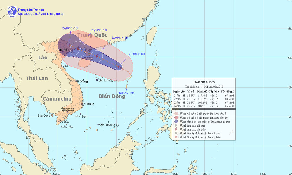
According to the Central Center for Meteorological and Hydrological Forecasting, early this morning (June 21), the tropical depression strengthened into a storm. This is the second storm to operate on the East Sea and has the international name of Bebinca.
At 13 o'clock, the location of the center of the storm is about 18.5 degrees north latitude; 115.4 degrees Kinh Dong, about 400 km from Hoang Sa archipelago to the East North East. The strongest wind in the area near the storm center is strong at level 8 (ie 62 to 74km per hour), level 9 and level 10 jerks.
It is forecasted that in the next 24 hours, the storm will move in the direction between Northwest and West Northwest, about 15 - 20km per hour. By 13:00 on June 22, the location of the center of the storm was about 20.3 degrees Vi Bac; 111.7 degrees east longitude, about 440km from Mong Cai (Quang Ninh) to the East of Southeast. The strongest wind in the area near the storm center is strong at level 9 (ie from 75 to 88 km per hour), level 10 and level 11 jerks.

The path of the storm Bebinca
In the next 24 to 48 hours, the storm is capable of changing the direction of travel in the West-Northwest direction, about 15km per hour. At 13 o'clock on June 23, the location of the center of the storm is about 21.5 degrees north latitude; 108.5 degrees east longitude, on Mong Cai area (Quang Ninh). The strongest wind in the area near the storm center is strong at level 8 (ie 62 to 74km per hour), level 9 and level 10 jerks.
In the next 48 to 72 hours, the storm continued to move in the West-Northwest direction, about 5 to 10 km per hour.
Due to the impact of storms, the northern sea area of the North East Sea, with strong winds of level 6, level 7, the area near the center of the storm passes through level 8, level 9, level 10 and level 11. The sea is very strong. In the Gulf of Tonkin waters from tomorrow afternoon (June 22), the wind will gradually increase to level 6-7, the area near the center of storm level 8, level 9, level 10, level 11. The sea is very strong. The coastal area in the North Eastern provinces from the morning of June 23 wind will gradually increase to level 6, level 7, the area near the center of strong typhoon level 8. In Northern provinces and North Central Vietnam, from the night of June 22, will be rain, moderate rain; Particularly, the Northeast area and the northern mountainous provinces have heavy to heavy rain.
In addition, due to the strong influence of the southwest wind zone, the Hoang Sa archipelago, the sea area from Binh Thuan to Ca Mau, the middle and southern part of the South China Sea (including the Spratlys) is southwest wind strong level 5, sometimes level 6, level 7, level 8 and showers and strong thunderstorms. The sea is rough. During thunderstorms tornado precautions required.
- Tropical depression on the South China Sea strengthened into a storm - storm Bebinca
- Bebinca storms can land in Hai Phong - Nghe An area
- East Sea is about to catch storms
- The South China Sea has big storms and tornadoes threatening the waters of Vietnam
- Three storms simultaneously threaten China
- Chinese fishing vessels escape storms thanks to the 'number sign
- Storm No. 2 is about 590 km from the coast of Quang Ninh and Hai Phong
- Tonight storms the provinces from Thai Binh to Thanh Hoa
- Typhoon attacks on Southeast Asia are getting stronger
- The South China Sea will suffer a series of major tropical storms
- The storm will become stronger and stronger
- Storm No. 4 changed direction and got stronger
 Is the magnetic North Pole shift dangerous to humanity?
 Washington legalizes the recycling of human bodies into fertilizer
 Lightning stone - the mysterious guest
 Stunned by the mysterious sunset, strange appearance