Bebinca storms can land in Hai Phong - Nghe An area
Today the storm surpassed Loi Chau Peninsula (China) and the possibility of landing provinces from Hai Phong to Nghe An on the morning of August 17.
Due to changing direction from East to West and moving slowly, Bebinca 7h this morning is still in the southern waters of Guangdong Province (China), the maximum wind speed is 90km / h, level 9, two levels of recoil.

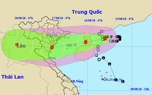
Predict the path and impact area of Typhoon Bebinca.(Photo: NCHMF).
The National Center for Meteorological and Hydrological Forecasting recognizes that the day and night of the storm in the West-South-West direction, the faster speed reaches 15 km per hour. By 7:00 am tomorrow, the storm center in the East of Bac Bo Bay, about 270-350 km from the coast of the provinces from Quang Ninh to Nghe An.
Due to the level 6 winds, level 8 jerks about 110 km from the center of the storm, today the North China Sea will have strong winds and strong seas. The dangerous area in the East Sea in the next 24 hours is north of the 19.5 parallel, east of longitude 108.
Entering the Gulf of Tonkin on the morning of August 16, Typhoon Bebinca keeps the speed of about 15 km per hour. At 7:00 on August 17, the storm center is in the coastal areas of Hai Phong - Nghe An provinces, the strongest wind is 75 km / hour, level 8, two-level shock. Range of strong wind level 6, level 8 shock about 100km from the center of the storm.
The storm then continued to hold the west-southwest direction, each hour was 15-20 km, went into the provinces from Hai Phong to Nghe An and weakened into a tropical depression, completely dissipated in Upper Laos area.
Forecast of Vietnam Meteorological Agency and Hong Kong, Japan stations, TSR (University of London, UK) today are similar in the way of storms. That is, instead of going up to the North, along the coast of Guangdong Province in the West, the storm was almost always swept from East to Southwest Southwest, passing by the Leizhou Peninsula.

Forecast of TSR Station (University of London, UK).
In terms of intensity and location of landfall, Hong Kong and TSR stations believe that the typhoon kept the winds of 63-118 km / hour when entering the area from Ninh Binh to Thanh Hoa. Vietnam Meteorological Agency offers two possibilities, one is to keep the maximum wind speed of 75 km / h (level 8), the other is to weaken into a tropical depression when entering the Gulf of Tonkin.
"Whatever the possibility, the North and North Central will have heavy rain from the night of 15 to the end of August 17 with the popular amount of 300-400mm, some places up to 600 m m," said Le Thanh Hai, General Department. National meteorological deputy meteorologist said yesterday afternoon.
In the context of June to July, rainfall in North and Central Vietnam is higher than the average of many years, with the number of times exceeding four times, the upcoming rain is likely to cause very high landslide. Rain will cause flooding in many low-lying areas. Downstream of Bui River in Chuong My District (Hanoi) can repeat the flooding situation as in the middle of July.
Earlier on August 8, low pressure areas in the Paracel Islands (Vietnam) formed, moved north, close to Hainan Island (China) and strengthened into tropical depressions. Due to the interaction with Typhoon Yagi toward Shanghai (China), the tropical depression is vicious in the southern waters of Guangdong Province (China) for several days.
In the morning of August 13, the tropical depression intensified into a storm, the fourth storm in the East Sea this year. After a slow moving day, the storm changes from east to west and forms two knotted rings along the way.
The forecast meteorological agency, the total number of storms and tropical depressions in the East Sea in 2018 is about 12-14 times, of which the number of inland land in Vietnam is about 4-6.
- Storm No. 2 is about 590 km from the coast of Quang Ninh and Hai Phong
- Tropical depressions are likely to become storms, towards Hai Phong - Nghe An
- Bebinca storms are getting stronger in the South China Sea
- Storm No. 2 landed in the North East: break dike in Hai Phong
- Storm No. 1 attacked Quang Ninh, Hai Phong
- Tropical depression on the South China Sea strengthened into a storm - storm Bebinca
- The Earth is about to lose 1/3 of its food land
- Nghệ An: The elephant of the attack attacked and killed
- Tonight storms the provinces from Thai Binh to Thanh Hoa
- Earthquake in Nghe An
- People in the North Central Coast fight against houses and anchors for storms
- Nghe An: The tiger's mother gave birth to a white child
 Is the magnetic North Pole shift dangerous to humanity?
 Washington legalizes the recycling of human bodies into fertilizer
 Lightning stone - the mysterious guest
 Stunned by the mysterious sunset, strange appearance