East Sea is about to catch storms
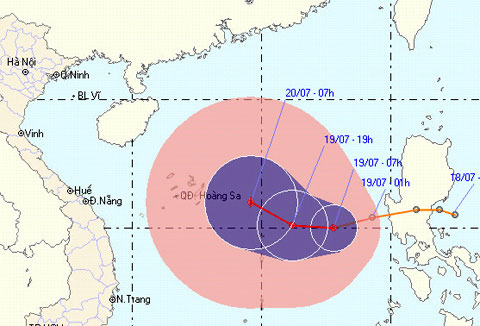
Tropical depressions formed the Philippine coast into the South China Sea and are getting stronger. This evening, the low pressure will strengthen into a storm.
One day after the formation, the tropical depression significantly increased and entered the South China Sea. This morning, the low pressure center is more than 600 km east of the Hoang Sa archipelago to the southeast of Vietnam with the strongest wind in the area near the center, reaching level 7, level 9.

Tropical depression is strengthening into a new storm, just two days after Typhoon Conson landed.Photo: NCHMF.
In the next 12 hours, the tropical depression moves in the West at a speed of 15 km per hour. By 19:00 tonight, a low pressure reached one level, became a storm and was about 470 km from Hoang Sa archipelago to the East of Southeast. From the center of the storm, the dangerous strong wind from level 6 or higher has a radius of about 200 km.
After strengthening, the storm stays the same but tends to change its direction to the north. In the morning, the storm is only 270 km away from Hoang Sa archipelago and can be further strengthened.
Under the impact of tropical depressions, the East Sea of the East Sea (including the Eastern Sea of the Paracel Islands) has strong winds of level 6-7. This afternoon, the wind will gradually increase to level 8-9, level 10 jerk.
- How was the storm in the East Sea formed?
- News of storm near the East Sea: Melor storm
- Tin storm on the East Sea: Typhoon Khanun
- The cause of sand storms raging throughout the Middle East
- A strong hurricane number 10 with level 12 approaches the land
- Strong storms appeared on the East Sea
- Danas storms level 10 toward the East Sea
- Super Typhoon Melor landed in the Philippines, 3 people died
- Three storms converge in northeastern East Sea
- Strong Banyan storm level 8 on the East Sea
- Tin storm on the East Sea - Storm No. 2
- Typhoon Ha Long may soon enter the East Sea
 Is the magnetic North Pole shift dangerous to humanity?
 Washington legalizes the recycling of human bodies into fertilizer
 Lightning stone - the mysterious guest
 Stunned by the mysterious sunset, strange appearance
 Super typhoon Manyi enters the East Sea, cold air moves slowly
  Storm No. 9 Manyi, level 12, about 200km from Hoang Sa archipelago
  Storm Tra Mi enters the East Sea today, strange movement direction
  The Da River fault zone causes earthquakes in Ninh Binh
  Sea levels are rising rapidly due to El Nino and climate change
  Tropical depressions appear into the East Sea, likely to become a typhoon