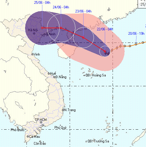
Tin storm on the East Sea - Storm No. 2
Tropical depressions on the East Sea have intensified into storms (storm No. 2). It is forecasted that the Northern provinces will have moderate rain, heavy rain, a place with very big rain, while the North is preparing for the rice harvest season, a crop is forecasted to be bumper .
>>> Tin low pressure near the East Sea
>>> Tin tropical depressions on the East Sea
In the afternoon of June 21, the typhoon No. 2 formed in the South China Sea and is expected to affect and cause heavy rain in the North in the next 2 days. According to the Central Steering Committee for Flood and Storm Control, this storm, like the tropical depression in 2008, turned into a storm and ran along the Vietnam-China border, with heavy rain and flash floods, causing heavy damage.
Meanwhile, the North is now preparing to enter the harvest season, a crop that is forecast to be bumper. This is a very worrying thing.

Map of the direction of the storm No. 2
In response to the situation, in order to proactively deal with the storm, on the afternoon of June 21, Deputy Prime Minister Hoang Trung Hai met with the Steering Committee for Flood and Storm Prevention to direct some emergency measures to respond to new developments. this.
Deputy Prime Minister Hoang Trung Hai requested forces and localities to be vigilant and take the initiative in taking precautionary measures . Especially in the northern mountainous provinces, it has been raining for the past 4 days and can be directly affected when the tropical depression turns into a storm, landing on land.
Localities organize a tally, grasp the number of boats operating in the South China Sea and promptly notify fishermen so they can avoid safe places, avoid subjective situation when distance and direction of storms appear. as little impact on Vietnam. Control and strictly handle vessels, especially tourist boats that violate the licenses and rescue equipment.
Industry and Trade and Agriculture sectors regularly inspect irrigation works and reservoirs. Transportation industry allocates rescue means to traffic in front of mountainous areas and critical areas.
Localities urgently harvest ripe rice fields, strengthen inspection and urge the implementation of the 4 contents on the spot, the proposed plans.
Also in the afternoon, the Steering Committee for Flood and Storm Control and Search and Rescue made an urgent call to the Steering Committee for Flood and Storm Prevention and Rescue and Searching for Provinces and Cities in the North and North Central and the Provinces sea from Ha Tinh to Kien Giang; Ministries, sectors: Agriculture and Rural Development, Defense, Transport, Environmental Resources, Industry and Trade, Construction, Health, Culture and Sports and Tourism, Finance, regular monitoring requirements, update the evolution of storms to actively prevent. Calling boats to shore safely .
In particular, the electricity company stated: The localities urgently harvest the ripe rice tea in the Northern Delta area according to the motto ' Greener than old people ' .
At 16 pm, June 21, the location of the center of the storm is about 19.4 degrees North latitude;115.5 degrees east longitude, about 350km from Hong Kong (China) south of Southeast.The strongest winds in the area near the storm center are strong at level 8 (ie 62 to 74 km per hour), level 9 and level 10 jerks.
It is forecasted that in the next 24 hours, the storm will move mainly in the direction of West and West Northwest, about 10 km per hour.
Due to the impact of storms, the North Sea in the East Sea has strong winds of level 6-7, the area near the center of the storm passes through level 8, shock level 9, level 10. The sea is strong.Hoang Sa archipelago area has heavy rain and thunderstorms.In a thunderstorm, there should be a tornado.From noon on June 23, the sea in the North of the Gulf of Bac Bo will gradually increase to level 5, sometimes level 6, shock level 7.From the evening of June 23 in the northern provinces, there is a moderate rain, heavy rain, there is a place where rain is very big and scattered with thunderstorms.
- Tin storm on the East Sea (storm No. 7)
- Storm No. 12 weakens into a tropical depression
- Hurricane Kalmaegi moves at a very fast speed
- Tin storm on the East Sea: Typhoon Khanun
- Storm No. 15 has not melted, near the East Sea, a new storm appears
- Typhoon Kalmaegi directly affects the North
- Typhoon Kalmaegi has entered the South China Sea, the country has scattered rain
- Storm No. 10 leaves the East Sea, still heading towards Vietnam
- A new storm appeared on the east sea, storm Pakhar
- A strong storm of level 14 appeared in the South China Sea
- 19h tonight, the storm center is located on the waters of Quang Ninh - Hai Phong
- A new storm appeared near the East Sea
 Is the magnetic North Pole shift dangerous to humanity?
 Washington legalizes the recycling of human bodies into fertilizer
 Lightning stone - the mysterious guest
 Stunned by the mysterious sunset, strange appearance