Typhoon Tembin jumped 13, the North warmed
After nearly a cold week, from now on, the temperature in the North increased gradually. At sea, Typhoon Tembin is working very hard, shocking level 13.
Weather of the day
Starting from last night, the heat of the whole North has increased by 2-3 degrees Celsius, in Hanoi it is popular at 11-14 degrees Celsius, the midland provinces are 8-11 degrees Celsius, and the mountainous areas are still below 5 degrees . In the early morning there was some fog in the sky.
By noon this afternoon, the heat in the day also increased by about 2 degrees, the highest in Hanoi reached 21-23 degrees C, Lang Son City 17 degrees, Tuyen Quang City 19 degrees . Sunlight lasts 8-9 hours However, the feeling of dryness still remains because the humidity remains low, sometimes only 35%.
From tomorrow, when the cold gas weakens further, the night heat in the North will continue to increase by about 2 degrees / night until the end of the week. Then from Monday the sky will be murky, cold again.
The area of Thanh Hoa - Thua Thien Hue is also warm, the highest in the day reaches 20-22 degrees, the cold night is 13-15 degrees.
Along Da Nang to Binh Thuan today, there continues to be rain, there is a place where the rain is very big and thunderstorms. The temperature in the Northern provinces holds at 19-22 degrees Celsius, 23-26 degrees south.
The Central Highlands and the South have scattered rains, in which the Central Highlands is cold 22-25 degrees, cold nights are 15-18 degrees. Southern Vietnam cool day 25-28 degrees, night and early morning cold 19-22 degrees C.
Typhoon Tembin

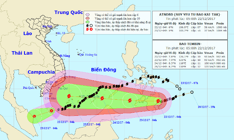
Typhoon Tembin continued to grow stronger and would enter the South China Sea for more than a day.
At 04:00 on December 22, the location of the storm center of Tembin is about 7.8 degrees North latitude; 126.1 degrees east longitude, in southern Philippines. The strongest wind is in the area near the center of strong storm level 10 (90-100km / hour), level 13 jerks.
It is forecasted that in the next 24 hours , Typhoon Tembin will move mainly in the West, fast moving speed (20-25km / h). At 04:00 on December 23, the location of the center of the storm is about 7.9 degrees North; 121.0 degrees east longitude, in southern Philippines, about 410km east of Pa-la-oan (Philippines). The strongest wind is in the area near the center of strong storm level 10 (90-100km / hour), level 13 jerks.
In the next 24 to 48 hours , Typhoon Tembin moved mainly in the West, moving quickly (20km / h) and has a stronger ability. At 04:00 on December 24, the location of the storm center is about 8.3 degrees Vi Bac; 116.0 degrees Kinh Dong, about 450 km from Truong Sa Lon (belonging to Truong Sa archipelago) to the East. The strongest wind is in the area near the center of strong storm level 10-11 (90-115km / hour), level 14 jerks.
In the next 48 to 72 hours , Typhoon Tembin moved mainly in the West, moving quickly (25km / h) and further intensifying.
- Typhoon Tembin lowered the level
- The sea was strong because of the influence of the circulation of storm Tembin
- Tembin stormed up and landed in our country tonight
- Typhoon Tembin made landfall in South Korea causing much damage
- Why say Typhoon Tembin is a catastrophic storm?
- Tembin storms into Ca Mau tonight
- Typhoon Tembin swept over, the DK1 rig shook
- Typhoon Tembin will cause waves as high as 9 meters into our country
- Why did Typhoon Tembin kill so many people in the Philippines?
- Severe typhoon level 16 is about to enter the South China Sea
- The North urgently resisted Typhoon Haiyan
- Typhoon Tembin weakened into a tropical depression
 Is the magnetic North Pole shift dangerous to humanity?
 Washington legalizes the recycling of human bodies into fertilizer
 Lightning stone - the mysterious guest
 Stunned by the mysterious sunset, strange appearance