Emergency storm (Typhoon Haitang)
Due to the influence of the circulation of typhoon No.4, Bach Long Vi island has strong winds of 14m / s (level 7), shocking 18m / s (level 8); in Con Co wind 11m / s (level 6), shocking 18m / s (level 8); Ly Son has 12m / s wind (level 6); jerk 17m / s (level 7); In the provinces from Quang Tri to Quang Nam, there is a big rain to very big, the rainfall from 26 to 1 hour on September 27 is popular in the range of 100-150mm; some places have heavier rains such as My Chanh (Quang Tri) 129mm; Thuong Nhat (Thua Thien Hue) 218mm; Nam Dong (Hue) 299mm; Cu Lao Cham (Quang Nam) 162mm .
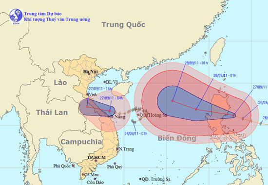
At 04:00 on September 27, the location of the storm center is about 16.7 degrees Vi Bac; 108.3 degrees Kinh Dong, on the coastal areas of Quang Tri - Thua Thien Hue provinces. The strongest wind in the area near the center of strong storm level 8 (ie from 62 to 74 km per hour), level 9 shock.
The path of the storm. (Click on image to see larger size)
It is forecasted that in the next 12 hours, the storm will move mainly in the direction of West-West and West-Northwest to travel about 20km every hour, weakening into a tropical depression, going to the mainland and continuing to weaken quickly into a low pressure area. . By 16:00 on September 27, the central position of the low pressure area is about 17.2 degrees Vi Bac; 105.6 degrees Kinh Dong, in Central Laos. The strongest wind in the center of the low pressure area falls below level 6 (ie less than 39 hours).
In the next 12 to 24 hours this depressive zone continues to penetrate the mainland, weakening and fading.
Due to the impact of storms in the Gulf of Tonkin, the waters of the provinces from Quang Tri to Thua Thien Hue today (September 27) also have strong winds of level 6 and level 7, the area near the center of the storm passes through level 8, jerks level 9. The sea is very strong. The coastal areas of the provinces from Ha Tinh to Thua Thien Hue have strong winds of level 6, shock level 7. In the provinces from Nghe An to Quang Nam, there is a moderate rain, heavy rain to very big.
In addition, due to the effects associated with the operation of the southwest monsoon, in the middle and southern part of the South China Sea (including the Spratly waters), the waters of the provinces from Binh Thuan to Ca Mau have strong winds of level 5. , at level 6, level 7 jerks and strong thunderstorms. The sea is rough. In a thunderstorm, there should be a tornado.
The next newsletter was distributed at 09:30 on September 27.
News broadcast at: 05h30
- Emergency dealing with Typhoon Haitang
- Emergency storm news (Storm No. 4) - updated
- Emergency storm news (Storm No. 4)
- The last news about storm No. 4
- Super typhoon Mangkhut is on a par with the super typhoon Haiyan
- Thousands of people were isolated due to flooding
- Super typhoon Irma, the strongest in 30 years, is about to attack the United States
- Road to storm No. 4 changes, stormy center to the coast of Ha Tinh - Da Nang
- Haiyan storm left Vietnam, at least 13 people died
- Typhoon Haiyan is heading into Quang Ngai
- Cyclone storm, typhoon typhoon and storm tropical storm What's the difference?
- Nakri is probably the strongest storm since the beginning of the year in the South China Sea
 Is the magnetic North Pole shift dangerous to humanity?
 Washington legalizes the recycling of human bodies into fertilizer
 Lightning stone - the mysterious guest
 Stunned by the mysterious sunset, strange appearance