Mujigae storms move faster and stronger
Central Center for Hydrometeorological Forecasting said that, due to the impact of the 4th storm, from this evening (October 4), the North Gulf of North Sea has strong winds of level 6-8, near the storm center level 9-10, level 11-12 jerk. High sea waves from 2-4m. The sea is very strong. Disaster risk level: Level 3.
Typhoon No. 4 moved quickly into the Gulf of Tonkin
From tonight, in the North-eastern provinces of the North and the northern mountainous areas, there is a moderate rain, heavy rain, a place with very heavy rain, Quang Ninh sea area gradually winds up to level 3-4, with thunderstorms all over the country.
According to meteorological experts, the storm No. 4 is considered a storm with fast moving speed, stronger and more complicated.

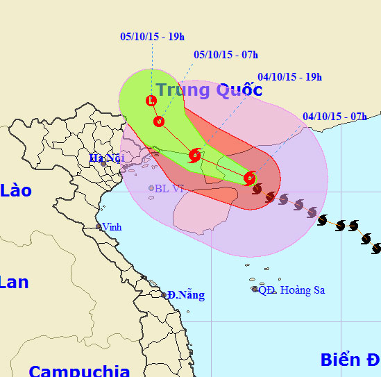
Mujigae's location and path.
The forecast begins in the afternoon and tonight, the storm will move into the Gulf of Tonkin and then land on our mainland. The area affected by typhoon No. 4 from Quang Ninh-Thai Binh.
Explaining the cause of typhoon No. 4 continuously increased and strengthened from level 8 to level 11 in just one day when entering the South China Sea, meteorologists said that: Storm No. 4 was heavily infused when entering the area. warm water of the South China Sea.
Due to the Northeast wind of weak cold air coming down, meet the East wind of subtropical high pressure block to the West. These two winds converge on the center of the storm No. 4, increasing the swirl so that the storm never stops stronger.
Due to the increasing influence of the storm No. 4, the branches, levels, local authorities and people need to be proactive, closely coordinated in the work of rescuing and preventing storms, minimizing damage. about people and property.
- Typhoon Mujigae is strong, winds are level 14, 15
- Mujigae stormed near the East Sea
- Typhoon Mujigae can land in Quang Ninh - Hai Phong
- Typhoon attacks on Southeast Asia are getting stronger
- The storm will become stronger and stronger
- Why chimp is 4-8 times stronger?
- Tropical storms are moving slowly and that is bad news for all of us
- Tropical depressions are likely to become strong storms towards the North
- The storm will become stronger and stronger
- El Nino comes back, hot summers and storms are stronger
- The lower gap is stronger, many areas in the North have heavy rain with thunderstorms
- Solar storms are stronger in the next 11 years
 Is the magnetic North Pole shift dangerous to humanity?
 Washington legalizes the recycling of human bodies into fertilizer
 Lightning stone - the mysterious guest
 Stunned by the mysterious sunset, strange appearance
 2024 Atlantic Hurricane Season Ends, Leaving Widespread Damage in Its wake
  Storm No. 9 Manyi, level 12, about 200km from Hoang Sa archipelago
  Video: Close-up of the terrible path of the Habood dust storm, causing 15 thousand people in the US to lose power
  Typhoon Tra Mi forms in the East of the Philippines, likely to strengthen into a hurricane when entering the East Sea
  Storm Trami will reach its maximum intensity when it approaches the Paracel Islands.
  Storm Tra Mi enters the East Sea today, strange movement direction