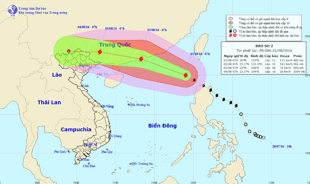
Hurricane 2 is shocking level 13-14 and continues to increase
At 08:00 on August 1, the location of the center of the storm is about 20.1 degrees North latitude; 118.9 degrees Kinh Dong, about 560 km southeast of Hong Kong. The strongest wind is in the area near the center of the storm with level 11 (105-120km / hour), shocking level 13-14.
It is forecasted that in the next 24 hours , the storm will move in the West-Northwest direction, about 25km per hour and will continue to increase. By 07:00 on August 2, the location of the center of the storm was about 22.1 degrees north latitude; 113.3 degrees Kinh Dong on the coast of Macau-Hong Kong. The strongest wind in the area near the storm center is strong at level 13-14 (135-165km / hour), level 16-17.
The East Sea in the East Sea has storms, strong winds of 8-11 level, the area near the center of the storm passes level 11-14, level 16-17. The sea was fierce. Level 3 disaster risk level.

Location and path of storm No. 2.
In the next 24 to 48 hours , the storm moves in the West-Northwest direction, 20-25km per hour. At 07:00 on August 3, the location of the storm center is about 23.0 degrees North latitude; 108.0 degrees east longitude, on mainland Guangxi province. The strongest wind is in the area near the center of strong storm level 8 (60-75km / hour), level 9-10.
The North Sea in the East Sea on August 2 also has strong winds of level 8-10, the area near the center of the storm passes level 11-13, level 15-16. The sea was fierce. Level 3 disaster risk level. Northern Gulf of Tonkin area from the evening of 2/8 strong winds of level 8-9. Strong sea. The North East North region has strong winds of level 6-7.
From the night of August 2 , in the North of the Northeast, there is a moderate rain and rain. Particularly, the Northeast area has a very big rain.
In the next 48 to 72 hours , the storm moved in the West, about 15-20km per hour.
In the North, there is a moderate rain to heavy rain, especially in the mountainous and midland areas, there is heavy rain.
In addition, because of the southwest monsoon activity, in the South China Sea region (including the Spratly waters), the offshore waters from Binh Thuan to Ca Mau have strong winds of level 5, sometimes 6, shock level 7-8. The sea is rough.
- On the evening of December 11, the 5th hurricane will land
- The last news about storm No. 3
- Storm No. 3 affects Nam Dinh and Thai Binh provinces
- Emergency response to hurricane Jebi
- Emergency storm (Typhoon Haitang)
- The last news about storm No. 4
- This afternoon, Typhoon Nesat landed in Quang Ninh - Nam Dinh
- Storm No. 10 entered Thanh Hoa-Quang Binh, the strongest in many years
- Evacuate people to avoid storm No. 6
- More than 30 people died from Hurricane Harvey
- Hurricane Nock-ten 'ensembles' South China Sea, wind gusts of level 14
- No. 6 hurricane weakens,
 Is the magnetic North Pole shift dangerous to humanity?
 Washington legalizes the recycling of human bodies into fertilizer
 Lightning stone - the mysterious guest
 Stunned by the mysterious sunset, strange appearance