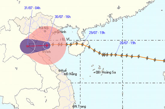
Storm No. 3 affects Nam Dinh and Thai Binh provinces
Due to the impact of storm No. 3, at Co To island station, there is strong wind of 15m / s (level 7), shocking 27m / s (level 10); At Bach Long Vi island station, there is strong wind of 20m / s (level 8), shocking 24m / s (level 9); Van Ly (Nam Dinh) 15m / s (level 6), shocking 22m / s (level 9); Thai Binh 12m / s (level 6), level 8 jerk.

At 16 o'clock on July 30, the location of the center of the storm was about 19.4 degrees north latitude; 106.1 degrees Kinh Dong, on the coast of Thai Binh - Ha Tinh provinces. The strongest winds in the area near the storm center are strong at level 8, level 9 (ie 62 to 88 km per hour), level 10 and level 11 jerks.
It is forecasted that in the next 12 hours, the storm will move mainly in the West, about 20km per hour. Thus, this evening (July 30), the center of the storm will enter the provinces of Thanh Hoa - Nghe An and weaken into a tropical depression, then the tropical depression continues to go deep into the mainland and continue to weaken into a low pressure area. At 04:00 on July 31, the central position of the low pressure area is about 19.3 degrees Vi Bac; 103.8 Kinh Dong, in Central Laos.
Due to the effects of storms, in the Gulf of Tonkin tonight (July 30), there are strong winds of level 6, level 7, storms near the center of the storm, level 8, level 9, level 10. Strong seas. The coastal areas of the provinces from Hai Phong to Nghe An have strong winds of level 6, level 7, the area near the center of storm level 8, level 9 and level 10. In the North East and North Central, there is moderate rain, heavy rain, there is a place where rain is very big and scattered. In a thunderstorm, there should be a tornado. The coastal areas of the provinces from Hai Phong to Nghe An need to watch for sea level rise in combination with high tide from 3 - 5m.
In addition, due to the influence of the southwest monsoon activity, in the middle and southern part of the South China Sea (including the Spratly waters), the waters from Binh Thuan to Ca Mau have strong winds of level 6. , level 7, level 8 jerks and showers and strong thunderstorms. The sea is rough. In a thunderstorm, there should be a tornado.
The next newsletter was broadcast at 21:30 on July 30.
Newsletter broadcast at : 17:30
- Typhoon is about to land in Thai Binh - Thanh Hoa
- Hurricane No. 3 moves quickly, landing in provinces from Thai Binh to Ha Tinh
- Urgently evacuate people during the night because of storm No. 10
- Tropical depression strengthened into a typhoon No. 5, heading to Binh Dinh - Phu Yen
- Tonight storms the provinces from Thai Binh to Thanh Hoa
- Phu Yen and Binh Dinh are disordered after Matmo storm
- This afternoon storms into the waters of Binh Dinh - Phu Yen provinces
- Lekima storm hit Nghe An - Ha Tinh
- Tonight the storm landed Hai Phong, Thai Binh and Quang Ninh
- 7 more provinces control bird flu
- Typhoon landfall in Quang Ninh - Nam Dinh, heavy rain up to 400mm, 4.0-4.5m rise
- Storm No. 2 is 110km from the mainland, the Central is heavy
 Is the magnetic North Pole shift dangerous to humanity?
 Washington legalizes the recycling of human bodies into fertilizer
 Lightning stone - the mysterious guest
 Stunned by the mysterious sunset, strange appearance