Typhoon is about to land in Thai Binh - Thanh Hoa
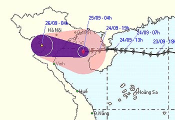
At 4 am this morning, the storm center is only about 200 km east of the coast of Hai Phong - Thanh Hoa provinces. This afternoon, afternoon and afternoon forecast, the storm center enters the provinces from Thai Binh to Thanh Hoa and weakens into a tropical depression.
According to the Central Center for Meteorological and Hydrological Forecasting, the wind near the center of the storm reaches over 74 km per hour. After making landfall and weakening into a tropical depression, the storm continued to move westward and weakened into a low pressure. From this morning, the coastal areas of the provinces from Quang Ninh to Thanh Hoa wind will gradually increase and the tide can rise 2-3 meters. The North and North Central provinces have moderate rainfall, heavy rain and flash floods and landslides.
The Border Guard Command said that by 13:00 on September 24, more than 17,000 ships with more than 100,000 fishermen knew the way of the storm to actively prevent and enter the safe harbor.
Today, Minister of Agriculture and Rural Development Cao Duc Phat, Head of the Central Steering Committee for Flood and Storm Control, will directly go to Hai Hau and Nam Dinh to direct flood and storm prevention and control.
At noon September 24, the storm No. 4 (international name, Francisco) with 72 km / hour winds landed on Hainan Island, China, making 5 missing fishermen.

The path of the storm was taken at 5:00 this morning. (Photo: NCHMF)
Invite readers to watch the video of the evolution of the storm No. 4 at 19h on September 24, 2007 on VTV1 television channel.
* Continue to update.
Tien Dung
- Tonight storms the provinces from Thai Binh to Thanh Hoa
- Noon 30/8, storm No. 4 went to the mainland from Thanh Hoa to Quang Binh
- Tonight the storm landed Hai Phong, Thai Binh and Quang Ninh
- Hurricane No. 3 moves quickly, landing in provinces from Thai Binh to Ha Tinh
- This afternoon and evening, the storm No. 4 will land in Ha Tinh - Quang Binh
- Typhoon Mirinae in Nam Dinh - Ninh Binh
- Why Thai Binh princess does not succeed Vo Tac Thien?
- Typhoon, flood, flooding raging
- Phu Yen and Binh Dinh are disordered after Matmo storm
- Urgently evacuate people during the night because of storm No. 10
- Haiyan storm turned to Thanh Hoa
- Typhoon hit Quang Binh - Quang Tri
 Is the magnetic North Pole shift dangerous to humanity?
 Washington legalizes the recycling of human bodies into fertilizer
 Lightning stone - the mysterious guest
 Stunned by the mysterious sunset, strange appearance