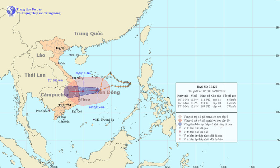
This afternoon storms into the waters of Binh Dinh - Phu Yen provinces
At 4 o'clock on October 6, the position of the storm center is about 13.9 degrees North latitude; 112.5 Kinh Dong, about 340 km from the coast of Quang Ngai - Phu Yen provinces to the East. The strongest winds in the area near the storm center are strong at level 8 (ie 62 to 74 km per hour), level 9 and level 10 jerks.
It is forecasted that in the next 12 hours, the storm will move in the direction of West and West Southwest, about 20km per hour. At 16:00 on October 6, the location of the center of the storm is about 13.7 degrees Vi Bac; 110.0 degrees Kinh Dong, on the waters of Binh Dinh - Phu Yen provinces. The strongest wind in the area near the storm center is strong at level 8 (ie 62 to 74km per hour), level 9 and level 10 jerks.

Location and path of the storm
In the next 12 to 24 hours, the storm moves mainly in the West, about 15 to 20km every hour, goes to the mainland and weakens into a tropical depression; then the tropical depression continued to go deep into the mainland and weakened into a low pressure area. At 4 o'clock on October 7, the central location of the low pressure area is about 13.6 degrees North latitude; 107.6 Kinh Dong, on the border area of Vietnam - Cambodia. The strongest wind in the center of the low pressure area falls below level 6 (ie below 39km per hour).
Due to the impact of storms, the sea area between Hoang Sa and Truong Sa archipelagoes has strong winds of level 6, level 7, the area near the center of the storm passes through level 8, shock level 9, level 10. Strong sea. In the waters of the provinces from Da Nang to Khanh Hoa (including Ly Son island district), the wind will gradually increase to level 6, level 7, the area near the center of the storm will pass through level 8, level 9 and level 10. From the afternoon and night of October 6, in the provinces from Quang Nam to Phu Yen, the wind will gradually increase to level 6, level 7, the area near the center of the storm passes through level 8, level 9, level 10; The North Central Highlands provinces have strong winds of level 5, sometimes level 6, level 7, level 8. In the provinces from Ha Tinh to Khanh Hoa and northern Central Highlands, there will be heavy rain to very big.
In addition, the cold air section in the North is still moving south. Around the evening and night of October 6, this cold air component will affect the weather in the Northern provinces. Due to the influence of cold air from the afternoon and tonight in the Gulf of Tonkin, there is a strong Northeast wind at level 5, sometimes at level 6, level 7 shock.
- The South China Sea has big storms and tornadoes threatening the waters of Vietnam
- Typhoon is about to land in Thai Binh - Thanh Hoa
- Entering the capital of Hanoi, the storm weakened into a tropical depression
- Tropical depressions cause heavy rain in the Central and Central Highlands
- Phu Yen and Binh Dinh are flooded again
- Excavation of Don Thu relic
- Tropical depression into storm Damrey, threatening Binh Dinh - Ninh Thuan
- Tropical depression strengthened into a typhoon No. 5, heading to Binh Dinh - Phu Yen
- Typhoon landed from Quang Ninh to Nam Dinh
- Binh Dinh 'asking for 100 billion dong to combat drought
- Binh Dinh: 2 more people died from floods
- Typhoon Nari approached the waters of the central provinces
 Is the magnetic North Pole shift dangerous to humanity?
 Washington legalizes the recycling of human bodies into fertilizer
 Lightning stone - the mysterious guest
 Stunned by the mysterious sunset, strange appearance