Evacuate people to avoid storm No. 6
Due to the impact of Typhoon 6 in Bach Long Vi with strong winds of level 12m / s (level 6), shocking 19m / s (level 8), in Hon Ngu (Nghe An) there is a wind gust of 15m / s (level 7); in Con Co (Quang Tri) there is a windstorm of 14m / s (level 7); Ky Anh (Ha Tinh) 15m / s (level 7), shock 27m / s (level 10).
>>> Thismorning, the storm started to cause rain in the Central region
In the Central provinces from Thanh Hoa to Thua Thien Hue, there is a moderate rain, heavy rain, a place with very big rain and thunderstorms with rainfall from 40 - 60mm; some places have heavier rains like Ha Tinh 85mm; Quy Hop (Ha Tinh) 188mm, Ky Lac (Ha Tinh) 205mm; Ba Don (Quang Binh) 104mm .
At 13:00 on August 7, the location of the center of the storm was about 18.9 degrees north latitude; 107.5 Kinh Dong level, about 190km from the coast of Hai Phong - Thanh Hoa provinces to the Southeast. The strongest winds in the area near the storm center are strong at level 8, level 9 (ie 62 to 88km per hour), level 10 and level 11 jerks.
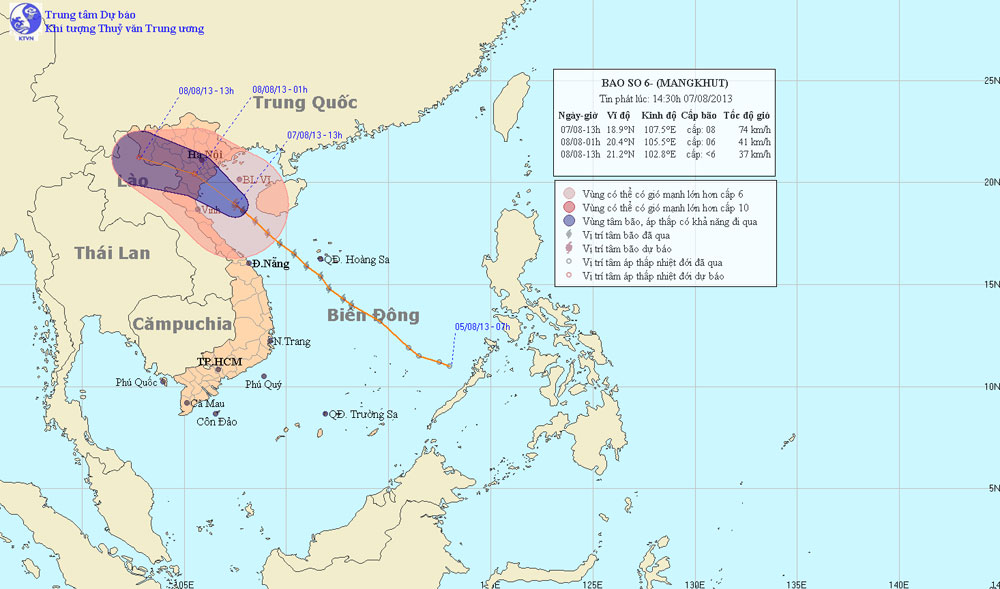
Photo of the path and location of the storm
It is forecasted that in the next 12 hours, the storm will move mainly in the direction of Northwest, about 20 - 25km every hour, going to the mainland of the coastal provinces of the Northern Delta - Thanh Hoa and weakening into a tropical depression. At 01:00 on 08/8, the position of the tropical depression center is about 20.4 degrees Vi Bac; 105.5 degrees east longitude, on the mainland of the southern provinces of the Northern Delta and Thanh Hoa. The strongest wind in the area near the strong center of level 6 (from 39 to 49 km per hour), level 7.
It is forecasted that in the next 12 to 24 hours, tropical depressions will be able to change direction in the direction of West-West to go into the mainland of Northern and Thanh Hoa provinces and weaken into a low pressure area. By 13:00 on 08/8, the central location of the low pressure area is about 21.2 degrees Vi Bac; 102.8 Kinh Dong level, on the Vietnam - Laos border area. The strongest wind in the area near the center of the low pressure area falls below level 6 (ie less than 39km per hour).
Due to the impact of storms, in the Gulf of Tonkin there is strong winds of level 6, level 7, the area near the storm center passes through level 8, level 9, level 10 and level 11. Coastal areas in the provinces of the North East, Thanh Hoa and Nghe An wind will gradually increase to level 6, level 7, near the storm center level 8, level 9, level 10. In North, Thanh Hoa and Nghe An have moderate rain, heavy rain to very big. Mountainous areas need to prevent flash floods and landslides. Coastal areas of provinces from Quang Ninh to Thanh Hoa prevent sea level rise combined with high tide of 3 - 4m.
- Big storm struck the Philippines, 74 people were killed
- Evacuate people along the river, lowland to a safe place
- How does lightning kill people?
- This evening, storm No. 5 landed on land from Quang Ngai to Khanh Hoa
- Storm devastated eastern China
- Japanese people evacuated because of the storm
- Big storms hit the Gulf
- Malaysia: Floods raging, 90,000 people evacuated
- Urgently evacuate people during the night because of storm No. 10
- The Philippines struggled with the consequences of two storms
- Typhoon Gaemi will land in Central Vietnam
- How did my father avoid the storm in the past?
 Is the magnetic North Pole shift dangerous to humanity?
 Washington legalizes the recycling of human bodies into fertilizer
 Lightning stone - the mysterious guest
 Stunned by the mysterious sunset, strange appearance