When is it called super typhoon?
There are many ways to calculate the level of wind in the turbulence in the Western Pacific. The understandings below are said to be commonly used by reliable meteorological agencies such as Japan, Hong Kong and the United States.
Differentiate storm levels
According to the regulations of the Western Pacific storms (areas with Vietnam).
- The wind does not exceed 63km / hour, so it is called a tropical depression.
- Wind power from 63-88km / hour: tropical storm (tropical storm).
- Wind from 89-117km / hour: intense tropical storm (severe tropical storm)
- Wind speed of 118km / hour or more: big storm (typhoon).
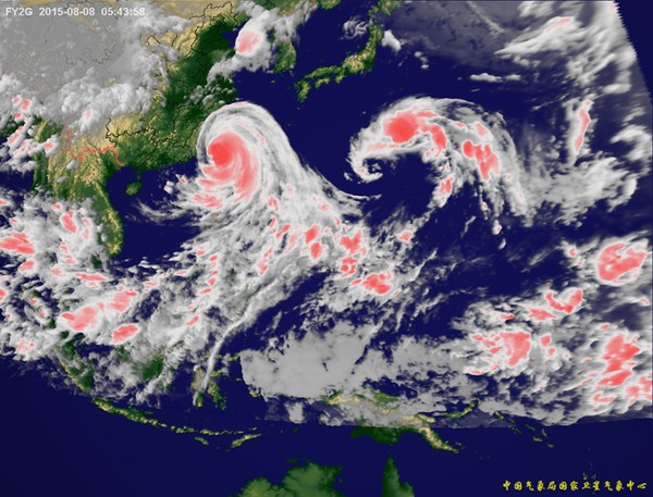
Satellite map of a storm.
It is also the Western Pacific region but according to the US Naval Joint Storm Warning Center, located in Guam, when the storm reaches winds above 115knot (213km / h), it is called super typhoon.
For the Saffir-Simpson scale for the Atlantic and Eastern Pacific regions , when the storm is above 117km / hour, it is divided by year of wind level. Accordingly, at level 1 the maximum wind power is in the range of 118 - 153km / hour, level 2 (154-177km / hour), level 3 (178-209km / hour), level 4 (210-249km / hour), and level 5 (over 250km / hour) is called ' super typhoon ' because winds exceed 249km / hour. Another rule is that when the pressure is below 920 HPA, it is classified as super storm.
Structure of storm
The main components of the storm include rain bands on the outer edge, the eye in the middle of the eye and into the eye of the storm located right next to the eye of the storm. In the lower half of the atmosphere, the moving air twists into the center counterclockwise, vertical movement upwards in the eye's eye and radiating out at the top in the opposite direction. In the center of the storm, the moving air descends, creating a cloudy area in the eye of the storm.
Eye of the storm
The eye of the storm is a relatively silent area, cloudy, with a diameter of about 30-60 km. When in a stormy area, people are often surprised when the wind and rain are very intense and suddenly stop, the sky is cloudy, it is when the eye of the storm passes.
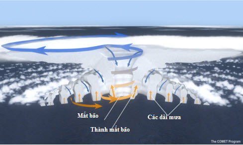
Figure 2: Storm structure diagram with basic components: storm eye, storm eye wall and twisted rain bands.
Stormy eyes
It is a thick cloud wall around the eye of a storm consisting of very high thunderclouds. This is the place with the strongest wind in the storm.
The twisted strip of rain
Rain clouds on the outer edge of the storm may be hundreds of kilometers away from the center of the storm. These dense patches of thunderstorms move slowly in a counterclockwise direction, ranging from a few kilometers to a few tens of kilometers and about 80 to 500 kilometers long.
The size of the storm
The characteristic size of the storm ranges from a few hundred kilometers, but can vary considerably. The size of the storm does not necessarily represent storm intensity.
- Why do a series of super storms suddenly appear around the world?
- The 10 biggest storms recorded in history
- The first super typhoon of 2014: Super typhoon Neoguri flipped on the sea
- Big storms destroy the world
- The steps needed to survive the super typhoon
- The North urgently resisted Typhoon Haiyan
- Hanoi plans to respond to super typhoon Mangkhut
- Millions of Indians face the biggest storm in decades
- Tang love covers Tacloban
- In the next 24 hours, the mind of the super typhoon Haiyan enters the waters of Hue-Binh Dinh
- Super storm Meranti landed, Taiwan was deserted
- Super storms appear near the East Sea
 Is the magnetic North Pole shift dangerous to humanity?
 Washington legalizes the recycling of human bodies into fertilizer
 Lightning stone - the mysterious guest
 Stunned by the mysterious sunset, strange appearance