Which provinces are the poles of Vietnam?
Have you ever wondered, where are the extreme East, West, South and North points of Vietnam? If you are wondering, please see the article below!
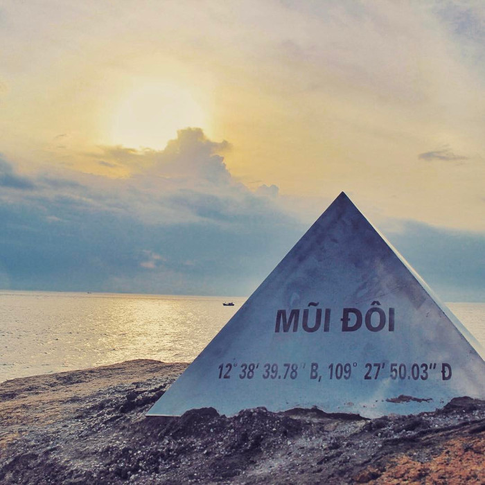
The easternmost point of Vietnam is located in Mui Doi in Khanh Hoa province
So far, there are still many controversies surrounding the issue of Twin Cape (Khanh Hoa) or Mui Dien (Phu Yen) which is the easternmost point of Vietnam. Many tour groups have come here and use GPS navigation devices to find answers to this problem. According to most people, it is acknowledged that Mui Doi in Khanh Hoa province is the first place to welcome sunlight in the territory of Vietnam.

The easternmost point of Vietnam.
- Double Cape - The easternmost point of the Vietnamese nation (continental part) - Belonging to Khanh Hoa province.
- Coordinates : 12 ° 39'21 "B 109 ° 27'39" D.
- Location : Mui Doi at Hon Gom peninsula, Van Phong bay, Van Thanh commune, Van Ninh, Khanh Hoa has coordinates of 12 ° 39'21 "North latitude and 109 ° 27'39" East longitude, is the point Easternmost on the mainland of Vietnam. The first place to receive the sun in the whole territory of Vietnam (Indochina and mainland Southeast Asia). This place has been recognized as a national monument by the Ministry of Culture, Sports and Tourism.
The westernmost point of Vietnam is located in A Pa Chai in Dien Bien province
Border gate of Pa Chai - Crossing Vietnam - Laos - China border is located in Sin Thau commune, Muong Nhe district, Dien Bien province.

The westernmost point of Vietnam.
Nearby cities: Lao Cai City, Ngoc Khe City, Ha Giang City
- Coordinates : 22 ° 25'49 "N 102 ° 11'3" E
- Vietnam's Westernmost landmark is a triangular border marker, with 3 sides written in Vietnamese - Lao - Chinese, built by China. The landmark is located in Ta mieu village - Sin Bid commune - Muong Nhe district - Dien Bien province.
The southernmost point of Vietnam is located in Mui Ca Mau in Ca Mau province

The southernmost point of Vietnam.
Ca Mau cape faces west, belongs to Mui Ne village, Dat Mui commune, Ngoc Hien district, Ca Mau province, more than 100 km from Ca Mau city. On the left of the nose is the East Sea, on the right is the West Sea, ie the Gulf of Thailand.
At present, in terms of geography, Ca Mau cape is not the southernmost point of Vietnam, but only in the southernmost region of Vietnam. The southernmost point on the mainland of Ca Mau province is located in Vien An commune, Ngoc Hien district, with a latitude of 8 ° 30 'North. Ca Mau Cape is the westernmost point of Ca Mau Province.
Previously some documents said that the southernmost point of land in Vietnam was Rach Tau village, also in Dat Mui commune, Ngoc Hien district, at latitude 8 ° 34 '(or 8 ° 30') latitude North, 104 ° 40 '(or 104 ° 50') East longitude.
The northernmost point of Vietnam is located in Lung Cu Peak in Ha Giang province

The northernmost point of Vietnam.
Lung Cu Peak - The Northernmost point of Vietnam Country - belonging to Ha Giang province - Latitude: 23 ° 22'59 "B - Longitude: 105 ° 20'20" Đ.
Lung Cu Commune consists of nine villages and hamlets, all at an average height of 1,600-1,800 meters above the sea surface. In these places in the winter it is very cold and there is snow. On the left side of the deep vein of the valley, about 50 hectares wide, on the right is the source of Nho Que river, originating from Mu Cang - Yunnan - China pouring into Dong Van, Meo Vac, mountains with majestic messages on the ranks most of the country.
- The two poles of the earth have the same species of creatures
- Three more provinces broke out of the flu
- Tropical cyclones tend to shift toward the two poles
- Why do animals avoid getting close to high voltage poles?
- VNPT adds head 3 to fixed numbers in 6 provinces
- Found this in the Arctic, the scientists are extremely worried
- Changes at the two poles of the Earth affect the climate
- Record the new distribution area of two amphibian species in Vietnam
- What if tomorrow woke up, all the ice on Earth would have melted?
- Digging holes to bury electric poles, discovering many ancient Le antiques in Ha Tinh
- Video: Earth has 3 north poles
- If the ice at the two ends completely, does the world sink completely in the sea of water?
 Is the magnetic North Pole shift dangerous to humanity?
 Washington legalizes the recycling of human bodies into fertilizer
 Lightning stone - the mysterious guest
 Stunned by the mysterious sunset, strange appearance