The latest development of Hurricane Melor
At 14 o'clock on December 16, the location of the center of the storm was about 14.5 degrees north latitude; 119.6 Kinh Dong, about 680km from Song Tu Tay Island (belonging to Truong Sa archipelago) to the Northeast. The strongest wind in the area near the storm center is strong at level 10 (ie from 90 to 100 km per hour), level 11-12 shock.
It is forecasted that in the next 24 hours , the storm will be able to change direction in the southwest direction, about 10-15km every hour, heading towards the Spratly Islands. By 13:00 on December 17, the location of the center of the storm was about 11.8 degrees Vi Bac; 118.2 degrees Kinh Dong, about 410 km from Song Tu Tay Island (belonging to Truong Sa archipelago) to the East North East. The strongest wind in the area near the center of the storm is level 8 (ie from 60 to 75km an hour), level 9-10.
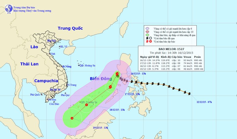
The path of Hurricane Melor.(Photo: NCHMF).
Due to the influence of storm circulation in combination with strong northeast wind, the East Sea area between the East Sea has strong winds of level 7-8, the area near the center of the storm passes through the 9-10 level, the shock level 11-12. Ocean waves 3-5m high. The sea is very strong. Disaster risk level: level 3.
In the next 24 to 48 hours , the storm moved in the southwest direction, about 25 km per hour and gradually weakened into a tropical depression. By 13:00 on December 18, the position of the tropical depression center is about 8.1 degrees North latitude; 113.3 degrees Kinh Dong, in the Spratly Islands area. The strongest wind in the area near the center of strong tropical depression at level 7 (ie from 50 to 60km per hour), level 8-9.
The area between the South China Sea (including the Spratly Islands) has strong winds of level 6-7, the area near the center of the storm passes through level 8, jolts 9-10. 2-4m high sea waves. The sea is very strong. Disaster risk level: level 3.
In the next 48 to 72 hours , tropical depressions move in the southwest direction, about 20km per hour.
- Hurricane Melor jerked level 17 is heading into the East Sea
- Typhoon Melor with the strongest winds of 185km / h towards the East Sea
- News of storm near the East Sea: Melor storm
- New storm entered the Philippines again when Melor just melted
- On the evening of December 11, the 5th hurricane will land
- Hurricane Parma challenges meteorologists
- Typhoon raging Japan
- Typhoon Parma and Melor are very strong and complex
- End of the season, the storm still poured into the Pacific Ocean
- Beam: Super storm Sandy devastated America
- Microsoft released Windows Server 2008 to the manufacturer
- More than 30 people died from Hurricane Harvey
 Is the magnetic North Pole shift dangerous to humanity?
 Washington legalizes the recycling of human bodies into fertilizer
 Lightning stone - the mysterious guest
 Stunned by the mysterious sunset, strange appearance