Based on where to forecast storms?
Last week, Typhoon Cimaron (Storm No. 7) made most of the meteorological forecasting centers in the world, including prestigious centers, have headaches about predicting the path of the storm. In fact, how does forecasting a storm happen?
Most countries in the world have formed many research and forecast centers for national and regional scale storms. So far, although studies on the cause of storm formation and development have obtained significant results, the forecast of the occurrence of tropical depressions and new storms is at a warning level. Only after the storm appears and can determine the central location of the low pressure area shown by the closed pressure line on the weather map, the task of forecasting the storm of the business is actually implemented.
To be able to provide periodic forecasts, forecasters need to have updated information on storms, including: atmospheric pressure field, wind field, direction and movement speed of storms . for previous periods. Usually the storm forecast period does not exceed six hours.
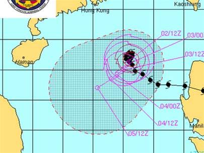
Hurricane Cimaron path 2006
Since the early years of the 20th century, storms have been discovered and monitored through the analysis of weather maps (synoptic) based on atmospheric pressure (air pressure), wind, clouds, rain data . - Receiving from stations, coastal monitoring stations, on islands, buoy stations and ships. Along with the ground pressure map, the atmospheric fields in the upper layers of the atmosphere are the basis for experts to make predictions about the path of the storm.
During the development of the storm, the ground and sea surface are the main sources of steam and energy for the storm. But this is a drag that weakens the storm. Therefore, in order to have a better storm forecast, it is necessary to have information such as ground topography, sea temperature .
Up to now, thanks to the meteorological and oceanographic monitoring system that constantly improves and technical advances, especially satellite remote sensing, provides constant information such as clouds, wind, sea temperature. Allows detection of storms from the beginning and its migration process. The storm and weather forecast now has strong support of digital models on high-performance computer systems, not only allowing analysis of the current state of storms and atmospheric - soil - marine factors. but it is also possible to provide direct forecasts of the path, storm intensity, scope and extent of their influence.
However, because these models have certain errors, including: method errors, errors due to input and errors due to calculation . so at the centers, people still predict See model results as a motivational aid for forecasters. Thus, the role of forecasters is always decisive because they have to analyze and synthesize many forecast results according to different methods and models, in order to make the most accurate decision.
Therefore, in the process of forecasting the recent Cimaron storm, different forecasting centers have produced conflicting results. Because the motivational aids they use are not the same, those responsible for forecasting cannot agree. These differences can only be overcome when the reliability of the forecasting models is more complete, the team of forecasters reaches a higher level of expertise. At the same time, when the ability to exchange information between domestic and foreign experts is extended, it will allow a better ' consultation ' before making a forecast.
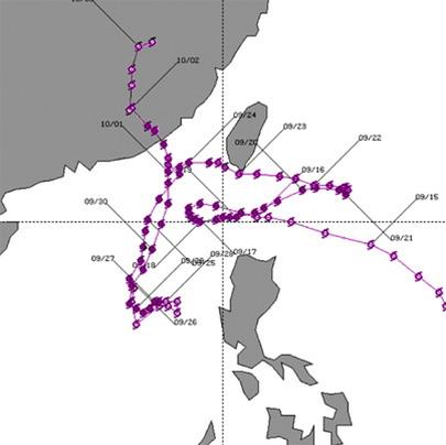
Typhoon Nat in 1991 had this complicated path!(Photo provided by Korea Meteorological Agency)
In Vietnam today, in limited physical conditions, the investment in building more centers for forecasting storms and modern weather is not necessary. The solutions that need to be given top priority are at the same time with the research and development of different forecast models, need to train highly qualified experts in the field of tropical storm forecasting.
The role of the South China Sea is not only important for economic development and security but also as a key factor in the development, development, operation and impact of tropical storms in our country. Therefore, it is inseparable from the requirement to study the storm forecast from scientific research on the South China Sea, including meteorology and marine climate.
Prof. Dr. TSNH VAN UU (Hanoi National University)
- Forecast is ... forecast
- This year may be more stormy than every year
- Tropical depressions approach the South China Sea, potentially increasing into storms
- Warning of giant storms on the Atlantic Ocean
- In 2012, the United States will be inundated with storms
- The woman predicted rain, storms thanks to ... headache
- Danas storms level 10 toward the East Sea
- Hurricane Podul, level 10, is heading into the South China Sea
- A strong solar storm occurred
- Tembin stormed up and landed in our country tonight
- The most dangerous storms in Vietnam
- In the morning of June 24, storms can cause flooding in Hanoi
 Is the magnetic North Pole shift dangerous to humanity?
 Washington legalizes the recycling of human bodies into fertilizer
 Lightning stone - the mysterious guest
 Stunned by the mysterious sunset, strange appearance