Develop tsunami warning method by GPS
A group of German scientists has successfully developed a faster and more accurate tsunami warning method using GPS, said Nature World News on May 18.
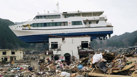
A yacht rushes to the roof of the house after the March 2011 earthquake and tsunami - (Photo: German Geological Research Center)
Accordingly, this method will provide early warning of tsunamis based on data from the Global Positioning System (GPS) to measure the deformation of the ground caused by earthquakes. This method is particularly effective for countries with large satellite networks, and can help scientists provide an accurate tsunami warning just minutes after the earthquake, much faster. compared to the traditional method.
Currently, the traditional tsunami warning method can take up to 10 minutes to calculate and transfer data collected from seismic recorders.
Studying the earthquake and tsunami disaster in Japan in March 2011, scientists said if the GPS system was used, the time to get accurate information about the height and intensity of the tsunami will save 3 minutes.
In this study, scientists used the raw data of Japan's GPS Earth Observation Network (GEONET) a day before the earthquake. To shorten the time needed for tsunami warnings, scientists only used 50 of the 1,200 GPS stations on Japan's east coast.
By using GPS data, scientists can use computers to simulate earthquake intensity and calculate tsunami height and intensity to give warnings.
- China developed a new tsunami warning system
- New method to forecast tsunamis
- India installed a tsunami warning system in the South China Sea
- Install 10 tsunami warning stations in Da Nang
- Why is the Indonesian tsunami warning not activated?
- Vietnam will join the International Tsunami Warning System
- Extend the tsunami warning system function
- Earthquake caused tsunami warning, radioactivity index was adjusted
- Indonesia has a new tsunami warning system
- Earthquakes followed the tsunami warning in New Zealand
- Test of Indian Ocean tsunami warning
- Japan's new
 Is the magnetic North Pole shift dangerous to humanity?
 Washington legalizes the recycling of human bodies into fertilizer
 Lightning stone - the mysterious guest
 Stunned by the mysterious sunset, strange appearance