Earthquake in the Philippines
An earthquake of magnitude 5.2 in the Richter scale occurred in the Philippines earlier but officials did not give a tsunami warning.

The seismic distance is about 105 km southwest of Olongapo city on Luzon island.Graphics: ask.com.
AFP quoted the US Geological Bureau as saying that the earthquake occurred at 2:29 local time (1:29 am Hanoi time) . Its epicenter is located 24 km deep and about 105 km southwest of Olongapo city on Luzon island. Currently Philippine officials have not announced the number of casualties and material damage.
Like Japan and New Zealand, the Philippines is on the Pacific Ring of Fire . This belt, about 40,000 km long and surrounds the Pacific Ocean, has many active volcanoes and tectonic grooves. About 71% of the strongest earthquakes occur here.
A milling line is located directly under the Philippine capital of Manila. Government earthquake researchers warn that people and Manila city authorities are not prepared to deal with a major earthquake.
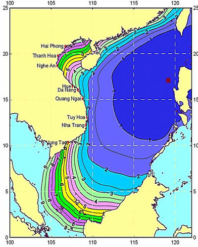
The time of tsunami propagation from the subduction zone of Manila to the coast of Vietnam.Photo: vast.ac
Yesterday an earthquake also occurred in northeastern Japan that killed three people and nearly 100 people were injured. Many buildings were destroyed and about three million households had no electricity to use. The US Geological Bureau said this was the aftershock of the March 11 earthquake, which left 12,700 people dead and nearly 15,000 missing.
- 6.4 earthquake struck the Philippines
- Earthquakes in the Philippines and Indonesia
- Earthquake in the Philippines
- The Philippines is in danger of recurring earthquakes
- Philippines: Earthquake in typhoon Haiyan
- The magnitude 7.2 earthquake in the Philippines killed 20 people
- Strong earthquakes in the Philippines and Indonesia
- Strong earthquake in Vanuatu, Philippines
- Philippines: earthquake, 5 people injured
- Earthquakes in the Philippines have killed 43 people
- Strong earthquakes occur in the Philippines and Taiwan
- Giant oars fish predicting earthquakes in the Philippines?
 Is the magnetic North Pole shift dangerous to humanity?
 Washington legalizes the recycling of human bodies into fertilizer
 Lightning stone - the mysterious guest
 Stunned by the mysterious sunset, strange appearance