Great Rift Valley Rift Great Rift
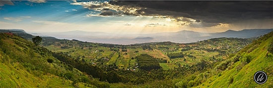
The splendor of the Great Rift valley in East Africa is made up of volcanic mountains, separated by barren wasteland and deep-bottomed lakes.
Stretching across 5,000 kilometers south, from Ethiopia to Mozambique, the Great Rift valley was formed 35 million years ago and continues to grow. It is called this large rift valley as a result of collisions between elements in the earth creating a large fissure on the surface of the Earth.
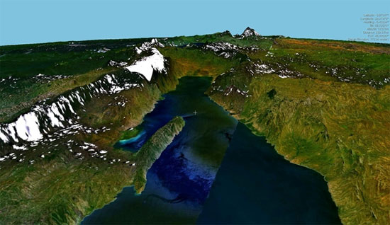
About 35 million years ago, at the depth of 3,200 kilometers underground in modern-day Ethiopia, near the melting center of the Earth, high temperatures and pressures pushed a mass of extremely hot liquid rock slowly to the surface. The appearance of the liquid rock created a tear that stretched to 1,600km above the ground and changed the terrain of a large area.
Abandoned mountains in Southeast Africa (across Ethiopia) - Eritrea or the basin of the Danakil Desert are the remains of ancient ruins. At this place, the crust is stretched out, creating many subsidence of up to 150m below sea level. In it, the basin of Danakil is the hottest place in the world when the cool breeze cannot blow and the temperature cannot escape.
After creating a crack, a powerful earthquake created a series of volcanoes, separating this land from the ocean. Under the scorching heat, water gradually evaporated and formed the Afar salt and desert. This is also the place where people go to exploit salt for 2,000 years.
- 7 natural wonders of Africa
- Explain why the lake is red like blood
- Lake system in a large cracked valley - World natural heritage in Kenya
- The soil cracked an unprecedented giant split the African continent
- The giant split in Africa is getting bigger and bigger, but what does this mean?
- Life in puddles
- Africa faces the risk of breaking in half: Cracks long thousands of meters are evidence
- The 'wand' detects the virus that transmits diseases to humans and animals
- Find a large valley with the Grand Canyon
- The appearance of huge fissures, evidence of Africa began to split into two, forming a new continent
- The Norwegian army is equipped with the Oculus Rift virtual reality glasses
- Climate change changes the evolution of mankind
 Is the magnetic North Pole shift dangerous to humanity?
 Washington legalizes the recycling of human bodies into fertilizer
 Lightning stone - the mysterious guest
 Stunned by the mysterious sunset, strange appearance