Latest news about storm No. 4
Update storm news number 4 on 25/7
Latest news about storm number 4 played at 11:00
Due to the influence of the circulation of typhoon No.4 in provinces from Thanh Hoa to Quang Nam with moderate rainfall, heavy rain, some places are very heavy rain like Ky Anh (Ha Tinh) 101mm, Dong Ha (Quang Tri) 68mm; At Hon Ngu (Nghe An), Con Co (Quang Tri), there is wind level 7.
At 11:00 on July 25 , the location of the center of the storm was about 17.1 degrees north latitude; 108.0 degrees Kinh Dong, on the waters of Ha Tinh-Quang Tri provinces. The strongest wind is in the area near the center of strong storm level 8 (60-75km / hour), level 9-10.
It is forecasted that in the next 12 hours , the storm will move in the West-northwest direction, about 15km each hour, go to the mainland of Ha Tinh-Quang Tri provinces and weaken into tropical depression. By 22:00 on July 26, the position of the tropical depression center was at about 17.5 degrees north latitude; 106.4 degrees Kinh Dong. The strongest wind power is in the strong tropical depression at level 6-7 (40-60km / hour), level 8-9.
It is forecasted that in the next 12 to 24 hours, tropical depressions will move in the west-northwest direction, about 15km each hour, going deep into the mainland and weakening into a low pressure area in Upper Lao area.

Direction of typhoon Sonca.
In today's day the danger zone (strong winds of level 6 or higher, rough seas) from latitude 16.00N to 19.00N; west of 109.00E meridian. The area near the center of the storm passes through the strong wind of level 8, level 9-10; ocean waves 3-5m high; strong sea.
The southern part of the Tonkin Gulf has strong winds of level 7, the area near the center of the storm passes through level 8, jerk level 9-10, strong seas; Ocean waves 3-5m high. Coastal areas of Ha Tinh, Quang Binh and Quang Tri provinces have strong winds gradually up to level 8, level 9-10; 2-4m high waves, strong seas; In coastal areas in the South of Thanh Hoa and Nghe An and Quang Tri provinces, strong winds gradually rise to level 6-7, level 8-9; High waves from 2-3m, strong seas. The tide associated with the tide in the coastal area from Nghe An to Quang Binh is 2-3m high.
From this afternoon , on the coastal areas of the provinces of Ha Tinh, Quang Binh and Quang Tri, strong winds gradually rise to level 7, level 8-9; in Nghe An and inland provinces, Ha Tinh, Quang Binh and Quang Tri provinces have strong winds of level 6, shock level 7-8; In coastal areas, Thanh Hoa and Thua Thien Hue provinces have level 6-7 winds.
Storm disaster risk level: level 3.
From July 25-27 , in the provinces from Thanh Hoa to Thua Thien Hue, there is a big rain to very big (popular 150-250mm in the whole period); In the Northern Delta, the provinces of Hoa Binh, Son La and the Central Highlands have moderate rainfall, heavy rain (popularly 50-150mm for the whole period).
In the middle and southern part of the South China Sea (including the waters of the Spratly Islands), the waters from Ninh Thuan to Ca Mau continue to have showers and thunderstorms, strong Southwest wind level 6, shock levels of 8-9, sea waves height from 2-3m, rough sea; Ca Mau to Kien Giang and the Gulf of Thailand have showers and scattered thunderstorms. In a thunderstorm that is likely to occur in a tornado, the wind gusts 6-8. Disaster risk level: level 1.
Latest news about storm No. 4 updated at 7pm
In the last 6 hours, the storm No. 4 continues to move mainly in the West.
At 04:00 on July 25, the location of the storm center is about 17.2 degrees Vi Bac; 109.3 Kinh Dong, about 290km from the coast of Ha Tinh-Quang Tri provinces to the East of Southeast. The strongest wind is in the area near the center of strong storm level 8 (60-75km / hour), level 9-10.
It is forecasted that in the next 24 hours , the storm will move west and northwest, about 15km per hour. This evening (July 25), the storm entered Ha Tinh - Quang Tri and weakened into a tropical depression. At 04:00 on July 26, the position of the tropical depression center was about 17.7 degrees North latitude; 105.8 Kinh Dong, on the Vietnam-Laos border area. The strongest wind is in the area near the center of strong tropical depression at level 6-7 (40-60km / hour), level 8-9.
In the next 24 hours, the danger zone (strong wind level 6 or higher, rough sea) from parallel 16.00N to 19.50N; west of meridian 111.00E. The area near the center of the storm passes through the strong wind of level 8, level 9-10; ocean waves 3-5m high; strong sea.
In the next 24 to 36 hours, tropical depressions move mainly in the West, about 15-20km every hour, continue to go deep into the mainland and weaken into a low area in the Northeast Thai region. Lan.

The path of the storm No. 4.
In the Gulf of Tonkin (including Bach Long Vi island district) with strong winds up to level 6, the area in the South of the Tonkin Gulf has strong winds of level 7, the area near the center of the storm passes through level 8, level 9-10, sea level. strong dynamics; Ocean waves 3-5m high.
From noon (July 25) , the coastal waters of Ha Tinh and Quang Binh provinces have strong winds gradually up to level 8, level 9-10; 2-4m high waves, strong seas; In coastal areas in the South of Thanh Hoa and Nghe An and Quang Tri provinces, strong winds gradually rise to level 6-7, level 8-9; High waves from 2-3m, strong seas. The tide associated with the tide in the coastal area from Nghe An to Quang Binh is 2-3m high.
From this afternoon, on the mainland coastal areas of Ha Tinh and Quang Binh provinces have strong winds gradually up to level 7, level 8-9; areas of Nghe An, Quang Tri provinces and inland provinces of Ha Tinh and Quang Binh provinces with strong winds of level 6, shock level 7-8; In the coastal areas of Thanh Hoa and Thua Thien Hue provinces, wind level 6-7 occurs.
Storm disaster risk level: level 3.
From July 25-27, in the provinces from Thanh Hoa to Thua Thien Hue, there is a big rain to very big (popular 150-250mm in the whole period); In the Northern Delta, the provinces of Hoa Binh, Son La and the Central Highlands have moderate rainfall, heavy rain (popularly 50-150mm for the whole period).
In the middle and southern part of the South China Sea (including the Spratlys waters), the waters from Ninh Thuan to Ca Mau continue to have showers and thunderstorms, strong southwest wind level 5, sometimes level 6, level 7 jerks -8, ocean waves from 2-3m high, rough seas; Ca Mau to Kien Giang and the Gulf of Thailand have showers and scattered thunderstorms. In a thunderstorm that is likely to occur in a tornado, the wind gusts 6-8. Disaster risk level: level 1.
Tin storm on 24/7
In the past 24 hours, the number 4 storm hardly moved.
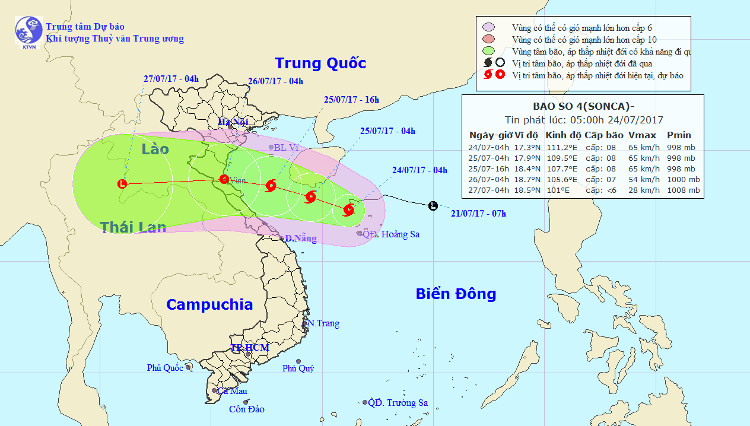
At 04:00 on July 24 , the location of the storm center is about 17.3 degrees Vi Bac; 111.2 degrees Kinh Dong, about 150km southeast of Hainan Island (China). The strongest wind is in the area near the center of strong storm level 8 (60-75km / hour), level 9-10.
It is forecasted that in the next 24 hours, the storm will move slowly in the West Northwest direction, about 5km per hour. At 04:00 on July 25, the location of the storm center is about 17.9 degrees North latitude; 109.5 Kinh Dong, right on the southern coast of Hainan Island (China). The strongest wind is in the area near the center of strong storm level 8 (60-75km / hour), level 9-10.
In the next 24 hours , the danger zone (strong winds of level 6 or higher, rough seas) from latitude 16,50N to 20,50N; west of meridian 113.00E. The area near the center of the storm passes through level 8, level 9-10; ocean waves 3-5m high; strong sea.
Location and direction of storm No. 4.
In the next 24 to 48 hours , the storm moved west-northwest, about 15km each hour, went to the mainland from Thanh Hoa to Quang Binh and weakened into a tropical depression. At 04:00 on July 26, the position of the tropical depression center was about 18.7 degrees North latitude; 105.6 degrees east longitude, on the mainland provinces from Thanh Hoa to Quang Binh. The strongest wind is in the area near the center of strong tropical depression at level 6-7 (40-60km / hour), level 8-9.
From tomorrow (July 25 ), in the Gulf of Tonkin (including Bach Long Vi island district) with strong winds up to level 6, the Southern Gulf of Tonkin area has strong winds of level 7, the area near the center of the storm passes through 8, shock level 9-10; waves from 3-5m high, coastal areas from Thanh Hoa to Quang Binh high waves from 2-3m; Strong sea.
In the next 48 to 72 hours , tropical depressions move mainly in the West, about 20km per hour.
Storm disaster risk level: level 3.
During the day and night today (July 24), there are rain in provinces from Quang Binh to Quang Ngai. From tomorrow (July 25), due to the impact of storms, in the provinces from Thanh Hoa to Thua Thien Hue, there is a heavy rain (100-250mm for the whole time). From July 25 evening and night in the Northern Delta, the provinces of Hoa Binh, Son La and the North Central Highlands have moderate rain and heavy rain (50-150mm for the whole period).
In the middle and southern part of the South China Sea (including the waters of the Spratly Islands), the waters from Ninh Thuan to Ca Mau have rainfall and thunderstorms, strong southwest wind level 5, sometimes level 6, level 7-8 shock. , rough sea; Ca Mau to Kien Giang and the Gulf of Thailand have showers and scattered thunderstorms. In a thunderstorm there is a possibility of tornado and a strong wind of level 6-8. Disaster risk level: level 1.
- How strong is Doksuri?
- Tropical depressions intensified into storm No. 10
- Tin latest No. 2 storm 9/7 and forecast for the next 10 days
- Storm No. 1 weakened into tropical depression, the North continued to have small rain
- Storm No. 10 entered Thanh Hoa-Quang Binh, the strongest in many years
- Emergency storm news (Storm No. 7)
- Tin latest storm No. 3: Lightning storms landed in Hai Phong - Ninh Binh
- Durian storm: Severe damage in Phu Quy island district
- Why is storm No. 10 the first storm in Vietnam to be warned red?
- Storm No. 10 approached the land of Ha Tinh - Quang Binh
- Typhoon Tembin will cause waves as high as 9 meters into our country
- The last news about storm No. 3
 Is the magnetic North Pole shift dangerous to humanity?
 Washington legalizes the recycling of human bodies into fertilizer
 Lightning stone - the mysterious guest
 Stunned by the mysterious sunset, strange appearance