Level 8 hurricane will affect Eastern North
Earlier, after entering the Gulf of Tonkin, the tropical depression was energized and strengthened into a storm - the No. 1 storm with the international name was Toraji.
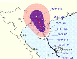
The central hydro-meteorological center said that 7am this morning, the center of the storm is about 200 km southeast of the coast of Quang Ninh - Hai Phong. The intensity of typhoons is strong at level 8, increasing by 1 level compared to yesterday (equivalent to 62 to 74 km per hour).
On the day and night, the storm moved in the northwest with a faster speed than yesterday (reaching 10-15 km / h) and passing Mong Cai, Quang Ninh province. Although not directly landing, but with a wide swirl, storms will affect the whole North East region.
This morning, in Hai Phong, Quang Ninh, it was still sunny. But according to the forecast, from this afternoon, in the two localities, the windstorm will be strong to level 7, the area near the center of the storm passes through the wind gust on level 8, it rains heavily. People need to prevent flash floods, landslides and cyclones.

Estimated path of storm.Photo: NCHMF (at 10:30 on July 5).
The northern provinces of the North in general, including Hanoi, from this afternoon the wind will also gradually increase to level 5, sometimes level 6, it rains. The Gulf of Tonkin is strongly impacted, stormy winds are above level 8.
Coastal provinces from Quang Ninh to Da Nang are urgently calling boats into shelters, arranging reasonable ships to avoid sea waves pushing and sinking. Northern mountainous provinces, especially in the Northeast, have made plans to relocate people living in areas likely to be affected by flash floods and landslides.
Hong Khanh
- No. 6 hurricane weakens,
- Level 14 typhoon is about to affect the North
- A strong hurricane number 10 with level 12 approaches the land
- On the evening of December 11, the 5th hurricane will land
- Cold air continues to affect the North Central
- Evening and tonight the cold air will affect the North, storm Nock-ten into the East Sea
- Typhoon Melor with the strongest winds of 185km / h towards the East Sea
- Emergency response to hurricane Jebi
- Cold air poured down North Central
- Beam: Super storm Sandy devastated America
- Storm No. 10 entered Thanh Hoa-Quang Binh, the strongest in many years
- Hurricane Hagupit raises level 12 straight to the East Sea
 Is the magnetic North Pole shift dangerous to humanity?
 Washington legalizes the recycling of human bodies into fertilizer
 Lightning stone - the mysterious guest
 Stunned by the mysterious sunset, strange appearance