NASA announces a high-quality map of the Antarctic region
Scientists from the US Aeronautics and Space Administration (NASA) have connected thousands of Antarctic photographs from satellites to create the most detailed and authentic maps ever made of this frozen land.
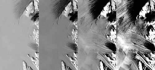
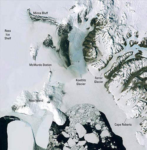
The map, named Antarctic Mosaic picture, was taken by Landsat, showing the southernmost continental region through realistic and clear details with a resolution 10 times higher than previous photographs.
This mosaic is made up of more than 1,100 photos taken with NASA's Landsat 7 satellite between 1999 and 2001. The only space on the map is a circle shaped like a donut on the South Pole. People can also see details about half the size of a basketball court, worthy of the most detailed map of Antarctica today.
According to Robert Bindschadler, head of research at the Biological Laboratory - Hydrology at NASA's Goddard Aerospace Aeronautics Center, this progress is as well as people giving up black-and-white televisions to switch to rewards. awake images of high-definition color TVs.'It is not merely a photograph, but a source of information about Antarctic transformation history over time and will help scientists continue to monitor the region's future changes.'
(Photo: LiveScience)
The first satellite images of Antarctica were taken in 1972 and much less detailed. Before that, people used planes and explorers to take photos of the Antarctic survey.
Researchers hope that this detailed map can help explorers plan more accurately and geologists study rock formation of the continent.
Bindschadler added: 'This map opens up a new horizon for scientific researchers as well as people who can better understand the Antarctic region. And also useful for scientists who have to use Antarctic images for research projects. '
(Photo: LiveScience)
- What is high-interest sample? Uses, dosage, side effects of high-quality samples
- Super high resolution of the new map of the icy continent
- Latest pictures of the Antarctic icy region
- Growing high quality Cara carat oranges in hilly land
- Antarctic travel in winter
- Epson announces DuraBrite Ultra saving ink
- The ice in Antarctica is continuing to thicken
- Successfully creating new high quality tea varieties
- Antarctic virus has a high level of genetic diversity
- NASA announces the best satellite image in 2011
- The warming climate affects the Antarctic food chain
- A 300km ice block suddenly melted in the Antarctic Peninsula
 Is the magnetic North Pole shift dangerous to humanity?
 Washington legalizes the recycling of human bodies into fertilizer
 Lightning stone - the mysterious guest
 Stunned by the mysterious sunset, strange appearance