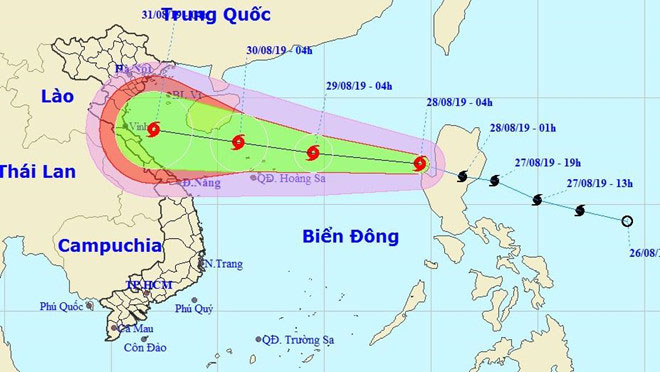
Podul storm into the East Sea, the wind 60-75km / h
Podul moved quickly and entered the South China Sea early on August 28. It is predicted that the storm will continue to strengthen and possibly enter the Tonkin Gulf in the next 2-3 days.
On the morning of August 28, Typhoon Podul moved quickly and passed the island of Luzon (Philippines) into the South China Sea. Currently, the strongest wind near the center of the storm reaches level 8, level 10. This is the fourth storm in the East Sea this year.
Over the next 24 hours, Podul is expected to move quickly to the northwest-west at a speed of 30 km / h and is likely to be stronger. On the morning of August 29, the storm center was 240 km to the east from the Paracel Islands with the strongest wind near the center reaching level 8-9, level 11.
Center for Hydrometeorological Forecasting has assessed that the influence of typhoons causes the northern sea area of the East Sea to have storms, strong winds of level 6-7, the area near the center of the storm going through strong level 8 and level 10; The sea is very strong.

The National Center for Hydrometeorological Forecast provides a forecast of the path of Podul after entering the East Sea area on the morning of August 28.(Photo: NCHMF).
Shortly thereafter, the storm kept moving in the direction but reduced the speed to 15-20 km / h and was likely to get stronger. By August 30, the storm center can be located right on the sea north of the Paracel Islands. The strongest wind near the center is strong at level 9, level 11.
At this time, the storm continues to slow down, only 10-15 km / h and continues to intensify. By August 31, the typhoon location is forecasted on the southern sea of Tonkin Gulf with the strongest wind reaching level 9-10, level 12 shock.
According to this development, typhoon No. 4 could reach our territorial waters and land, affecting the weather in the North and the North Central Coast during the National Day holiday on September 2. The Central Steering Committee for Natural Disaster Prevention and Control has dispatched an emergency power to request localities from Quang Ninh to Phu Yen to prepare an emergency response plan for Typhoon Podul to hit Vietnam.
The local Steering Committee for Flood and Storm Prevention and Control should coordinate with departments, branches to strictly control the sailing and maintain regular contact with vessels operating in the area affected by the storm.
Currently, the North has showers and many thunderstorms. Mountainous areas with heavy rain with a common volume of 60-100 mm. Until the night of August 28, the influence of the low-pressure ditch combined with the wind convergence caused the Northern region to continue to show showers, the local area of heavy rains accompanied by tornadoes of lightning and strong winds.
Tonight and tomorrow, the Hanoi area is forecast to rain with strong winds .
- Hurricane Podul, level 10, is heading into the South China Sea
- Aere storm jerks 10-12 levels into the South China Sea
- In the morning, Typhoon Podul landed in the Central Region
- Aere storm entered the South China Sea
- Noon 30/8, storm No. 4 went to the mainland from Thanh Hoa to Quang Binh
- Typhoon Mirinae - Storm No. 1 toward Hai Phong
- Podul storm threatened the central provinces
- Podul storm landed in Quang Binh
- Hurricane Podul, level 10, is heading into the South China Sea
- Danas storms level 10 toward the East Sea
- Storm No. 2 causes showers and thunderstorms, with tornadoes, wind gusts of level 10
- Bopha storm is active strongly near the South China Sea
- Tin storm near the shore: Storm No. 3 appeared, heading to Da Nang - Quang Ngai
 Is the magnetic North Pole shift dangerous to humanity?
 Washington legalizes the recycling of human bodies into fertilizer
 Lightning stone - the mysterious guest
 Stunned by the mysterious sunset, strange appearance