Preventing forest fires from satellites
This system is based on GIS technology (Geographic Information System) and remote sensing image .
Application of GIS technology to forest fire prevention
In the framework of cooperation between Hai Phong City People's Committee and Vietnam Academy of Science and Technology, Institute of Geography (Vietnam Academy of Science and Technology) has just handed over to Hai Phong a system of forest fire warning software. Cat Ba island.
This system is based on GIS technology (Geographic Information System) and remote sensing image will directly support forest management and forest fire prevention in Cat Ba National Park (National Park).
Every year, wildfires are burning
Hai Phong has about 20,000 hectares of forest, of which more than 10,000 hectares are special-use forests, the rest are protection forests.
In recent years, in addition to the system of documents forming legal corridors in forest protection, the city also directs the agencies, functional units and localities to focus on fire prevention and treatment. Forest fires.
However, every year, forest fires occur, causing forest strips, from young forests (newly planted) to old forests (primeval) to always be at risk of being 'wiped out'.
Most of Hai Phong's forest area is currently interspersed among residential areas, located in many tourist areas, so the fire often occurs due to lack of awareness among people and tourists.
Cat Ba National Park has a total area of more than 16,000 hectares of natural land with wide, complex and dangerous terrain, many easy to penetrate gateways, making it very difficult to prevent and fight forest fires.
Cat Ba forest is considered to be a unique forest on limestone mountains of the Northeastern region of our country. The park has a high level of biodiversity with over 3,000 species of flora and fauna, so the recovery from forest fires here is usually very long.
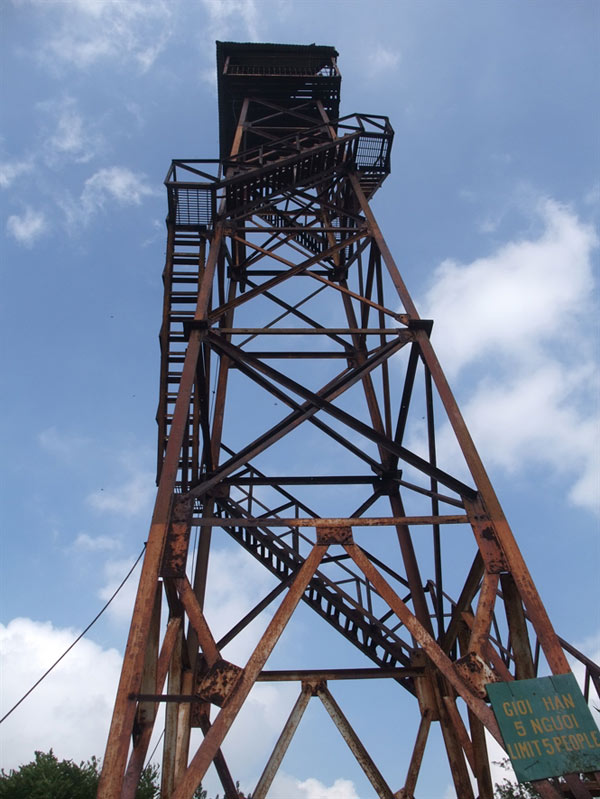
A forest guard tower at Cat Ba National Park
In recent years, Cat Ba has been in constant fire. In 2001, there were 2 forest fires, 11 cases in 2004, 17 cases in 2007, 2 cases in 2014 . Especially, only 40 days in early 2009, there were 6 special-use forest fires in the commune: Phu Long, Tran Chau and Cat Ba town.
According to the assessment of the Cat Hai District Forest Protection Department, this is the time and the year with the highest number of forest fires in the locality in the last 20 years.
Although most of the fires are small-scale, the area of forest damage is not large, but the environmental and environmental consequences are not small, especially when the forest fire area is located in the area of tourists coming. visit regularly.
According to Do Xuan Thiep, Deputy Head of Cat Ba National Park Forest Protection Department, most forest fires are due to lack of awareness of people causing forest fires.
It may be due to smoking, throwing away cigarette butts that cause forest fires , even in many cases due to personal enmity that has burned contracted forests of the victims. Forest fires in Cat Ba usually occur from November to April next year.
In recent years, forest rangers have strengthened guard patrols, applied and propagated and mobilized people to protect forests.
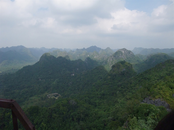
Cat Ba National Park looks from a forest guard
According to MSc. Do Minh Phuong, Institute of Agricultural Planning and Design (Ministry of Agriculture and Rural Development), needs a comprehensive solution system to prevent forest fires and protect the ecological environment for Cat Ba National Park area.
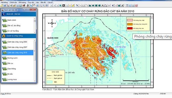
MSc. Do Minh Phuong said that it is necessary to set up a fire prevention forecasting system at the observation stations of Cat Ba National Park with advanced facilities such as geographic information systems, remote sensing images , to provide data Warn locations and areas at high risk of forest fires.
In order to be more active in this work, in addition to doing well the propaganda, raising people's awareness , regular forest rehabilitation, strengthening forest patrolling, Hai Phong needs to invest more in building forces and equipment for forest fire prevention and fighting.
Technology Solutions
In response to the practical requirements, Hai Phong City People's Committee has 'ordered' the Institute of Geography to build an electronic database system for forest resources and software to warn forest fires in Cat Ba island.
The system is designed in the form of a multimedia electronic Atlas that works on personal computers, including the main components of maps, images, audio, video, description information about love image of forest resource management in Cat Ba island.
Besides, the system also has a model of forest fire warning based on GIS data and weather .
In the coming time, GIS and remote sensing technologies will be strengthened in agriculture (building maps of water resources, crops and calculating vegetation indexes throughout the territory to make drought forecasts; supervise and forecast the situation of production of key crops and aquaculture, control marine fishing vessels, monitor floods and natural disasters .).
The model is calculated from input maps such as temperature, humidity, vegetation, wind, terrain direction, slope . These parameters were established from the interpretation of satellite images, numbers. whether stations are measured and downloaded directly from NASA's weather forecast center (US Aeronautics and Space Agency) via the Internet.
Mr. Do Xuan Thiep said that this system is very meaningful for Cat Ba National Park. It allows forecasting areas of forest fire risk based on scientific calculations, giving fast and up-to-date predictive results.
Although the system does not directly prevent forest fires from occurring, it is possible to map areas of high risk of forest fires and assess the level of danger, helping managers to develop forest fire prevention and control solutions and propose a more effective forest fire management plan. The software also supports the detection of forest fires at the present time.
Mr. Nguyen Van An, Director of Hai Phong Department of Science and Technology, said that the expert group has collected the latest and most accurate practical data set to create the reliability of the inputs for software construction. forecast the risk of forest fire in Cat Ba Island.The forecast results are highly reliable and have practical value.
The Institute of Geography said that GIS and remote sensing technologies are being applied in forest fire prevention and control in Lao Cai, Hai Phong, Phu Yen and Quang Ninh .
- NASA uses 200 satellites to detect forest fires in 2018
- Satellite detection of forest fire
- Singapore is concerned about forest fires in Indonesia
- 'Fire attack' raged in America, thousands of people evacuated
- Fireproof blanket - new fire protection method?
- Intense wildfire creates cloud of fire, the sky turns red orange 'like the end of the world'
- Video: Fire in the wild forest in southern Australia
- Indonesian wildfire is blackening the skies of Southeast Asian countries
- Smoke and forest fires are assassins with humanity
- Dozens of large wildfires broke out in Australia
- Successful fabrication of the gel can prevent forest fires
- Forest fires continue to rage in European countries
 'Barefoot engineer' invents a pipeless pump
 Process of handling dead pigs due to disease
 Radiometer
 Warp Engine: Technology brings us closer to the speed of light