Projects that change the face of traffic in the capital
After 70 years of liberation, Hanoi has built Noi Bai airport, two urban railway lines, many belt lines, radial axes and expressways connecting to neighboring provinces.

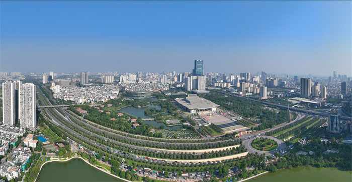
Thang Long Avenue was opened to traffic in October 2010, on the occasion of the 1,000th anniversary of Thang Long - Hanoi. This is a radial axis connecting the center of the capital with the western districts. The 29 km long route includes two expressways and two service roads. On the expressway, each direction has two lanes with a maximum speed of 100 km/h, one lane with a speed of 80 km/h and an emergency lane. The service roads each direction have two mixed lanes with a maximum speed of 50 km/h. Photo taken at the beginning of the avenue, the section passing the National Convention Center, Nam Tu Liem District.

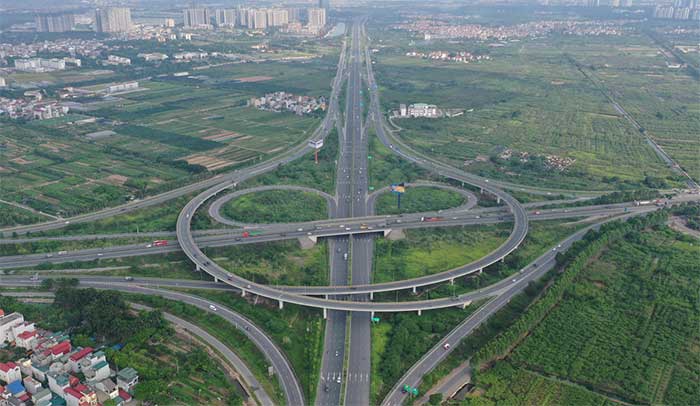
Hanoi - Hai Phong Expressway is the first expressway in Vietnam built according to international standards, connecting Hanoi with the seaport areas of Quang Ninh and Hai Phong. The route is 105 km long, of which the part passing through Hanoi is 6 km long, the rest passing through Hung Yen, Hai Duong, and Hai Phong. The road surface is 32.5 m to 35 m wide with 6 lanes, designed speed of 120 km/h. Photo taken at the right turn onto the expressway, Long Bien district.

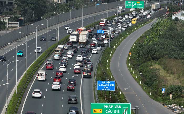
Phap Van - Cau Gie is 29 km long, with 6 lanes, and is a vital highway in the south of the capital with a daily traffic volume of about 70,000 vehicles. According to the plan, the road will be expanded to 8 lanes before 2030.

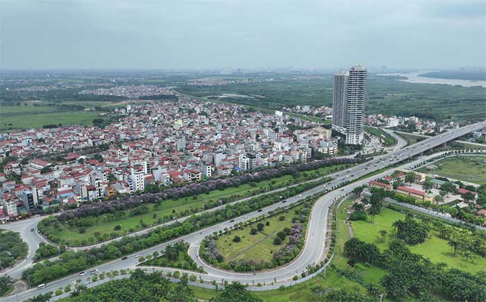
Vo Nguyen Giap Street is one of the most modern routes in Hanoi, connecting the city center with Noi Bai airport. In the future, along both sides of the road will be the new administrative center of Dong Anh district with the highlight being a 108-storey tower. The 16 km long road is designed with 6 lanes and 2 emergency lanes, cars can run at a maximum speed of 90 km/h. On both sides are service roads for mixed vehicles. Photo taken at the section passing through Dong Anh district.

Beltway 2, according to the plan, is 38 km long, starting from Minh Khai slope to Nga Tu Vong - Nga Tu So (photo) - Duong Lang - Cau Giay - Buoi - Lac Long Quan - Nhat Tan dike and crossing the Red River from Phu Thuong commune to Vinh Ngoc commune, through Dong Hoi, Dong Tru, National Highway 5, continuing to cross the Red River at Vinh Tuy, connecting to Minh Khai slope to form a closed belt. Currently, Beltway 2 is basically half completed south of the Red River, the north has a section from Chui bridge intersection to Vinh Tuy bridge. From January 2023, more than 5 km of the elevated road from the south of Vinh Tuy bridge to Nga Tu So intersection will be opened to traffic, contributing to solving traffic congestion in the inner city.

Beltway 3 starts from North Thang Long - Noi Bai road to Mai Dich - Thanh Xuan - Phap Van - Sai Dong - Phu Dong bridge - Ninh Hiep - runs parallel to Hanoi - Thai Nguyen expressway, continues south of the beltway railway to connect with North Thang Long - Noi Bai in Quang Minh area to form a closed route. Photo taken at the intersection of Beltway 3 with Chu Van An street. The route has many old sections, the newly built elevated road from Thang Long bridge to Thanh Tri bridge has been completed, helping vehicles go in all directions without having to go through the center. Beltway 3 is always crowded, about 124,000 vehicles per day. Beltways 2 and 3 passing through the inner city are designed as expressway overpasses.

In addition to Thang Long Avenue, Hanoi also has the Le Van Luong - To Huu radial axis and a number of roads under construction such as Tay Thang Long, Ho Tay - Ba Vi, Ha Dong - Xuan Mai, Tu Lien - Hanoi - Thai Nguyen expressway. In addition to solving urban traffic problems, along the radial roads under construction, many new urban areas, offices, and commercial centers are emerging.

Noi Bai Airport is located in the north of the capital, about 40 km from the center, and is an aviation gateway connecting the country and the world. The airport has two operating runways measuring 3,200x45 m, capable of receiving large aircraft such as Boeing 747 and Airbus 380. Noi Bai has two domestic terminals T1 and T2 with a capacity of 25 million passengers per year, but in 2023 it welcomed nearly 30 million passengers, the second largest in Vietnam after Tan Son Nhat. Terminal T2 is being invested in expansion so that the airport can welcome 40 million passengers per year. (Photo: Phan Cong).

The Cat Linh - Ha Dong urban railway is 13 km long, running above 12 stations. Each train has 4 carriages, carrying 960 people, with a maximum speed of 80 km/h and an operating speed of 35 km/h. The train's entire journey is 23 minutes. In November 2021, the Cat Linh - Ha Dong metro line was put into operation after 10 years of investment and construction. After 3 years of operation, this line has attracted a large number of people, carrying 35,000 passengers every day, of which 47% are commuters, 45% are students and 8% are traveling for other purposes. The metro line has contributed to reducing private vehicles, solving traffic congestion in the southwest of the capital and reducing environmental pollution.

The Nhon - Hanoi Railway Station urban railway line is 12.5 km long, with 8 elevated stations and 4 underground stations. Of which, the Nhon - Cau Giay elevated section is 8.5 km long, the Cau Giay - Hanoi Railway Station underground section is 4 km long. On August 8, the Nhon - Cau Giay elevated section was put into commercial operation. In the first week of operation, this route welcomed more than 100,000 visitors. The Nhon - Hanoi Railway Station is expected to contribute to solving traffic congestion in the west of the capital, changing the urban landscape.

The project changes the face of traffic in the capital. (Graphics: Dang Hieu).
- The mystery of the human face
- Climate change: Dangerous for buildings
- Synchronize traffic lights to avoid traffic jams
- Traffic lights change color according to situation
- New system to replace traffic lights, promises to save 20% of traffic time
- Model of people who can survive in traffic accidents
- Facebook has face recognition technology like the human eye
- No accident, no road repair, why is there still a traffic jam?
- The French capital restricts traffic because of air pollution
- Smart intersection without traffic lights
- Tunnel through the Alps
- Virtual traffic jams: The new obsession of modern times!
 Norway built the world's tallest wooden tower
 Kremlin
 Ashurbanipal: The oldest royal library in the world
 Decoding the thousand-year construction of Qin Shihuang shocked the world