Storm Nari threatened, many Central people evacuated
Due to the influence of the 11th storm circulation, at Ly Son island station, the strong wind of 19m / s (level 8) was measured, shocking 28m / s (level 10).
>>>Storm Nari is approaching the waters of the Central provinces
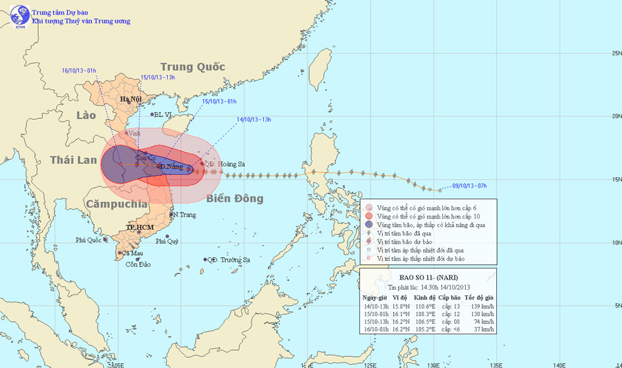
At 13:00 on October 14, the location of the center of the storm was about 15.8 degrees Vi Bac; 110.6 Kinh Dong, about 220km from the coast of Quang Tri - Quang Ngai provinces to the East. The strongest wind in the area near the center of the storm is level 13 (ie from 134 to 149 km per hour), level 15 and level 16 jerks.
In the next 12 hours, the storm will move in the direction of West and Northwest Northwest, about 10 - 15km per hour. By 01:00 on September 15, the location of the center of the storm was about 16.1 degrees North latitude; 108.3 degrees Kinh Dong, right on the coast of Quang Tri - Quang Ngai provinces. The strongest winds in the area near the storm center are strong at level 12 (ie between 118 and 133 km per hour), jerky level 13, level 14.

Image of the path and location of Typhoon Nari
In the next 12 to 24 hours, the storm moves mainly in the West, about 10 - 15 km every hour. By 13 o'clock on October 15, the location of the storm center is about 16.2 degrees Vi Bac; 106.5 degrees Kinh Dong, in southern Laos. The strongest winds in the area near the storm center are strong at level 8 (ie 62 to 74 km per hour), level 9 and level 10 jerks.
In the next 24 to 36 hours, the storm continued to move mainly in the West, about 10 to 15 km every hour, going deep into the mainland and weakening into a tropical depression, then the tropical depressions continued. keep weakening into a low pressure area. At 01:00 on October 16, the central position of the low pressure area is about 16.2 degrees Vi Bac; 105.2 Kinh Dong, on the Laos - Thailand border area. The strongest wind in the center of the low pressure area falls below level 6 (ie less than 39 km per hour).
Due to the impact of storms and the sea area of Hoang Sa archipelago today (October 14), there are strong winds of level 9, level 10, the area near the storm center passing through level 12, level 13, level 15 and level 16. Sea violently. The Southern Gulf of Tonkin, the waters off the provinces from Quang Tri to Binh Dinh (including Ly Son and Con Co islands) have strong winds of level 7, level 8, and then rise to level 10, level 11, region near the storm center, pass through level 12, level 13, level 15, level 16. The sea is fierce.
From this evening (October 14), provinces from Ha Tinh to Quang Ngai have strong winds of level 6, level 7, areas near the storm center of 10-12, level 13, level 14. In provinces from Thanh Hoa to Quang Ngai and North Central Highlands have moderate rain, heavy rain to very big. Provinces from Ha Tinh to Quang Nam prevent sea level rise combined with 3 - 4 meter high tides.
- Nari storm devastated the Central region
- Actively respond to storm Nari
- Typhoon Nari landed in Danang, Central Vietnam with heavy rain
- Storm Nari advanced quickly into the South China Sea
- Strong Nari Storm 11 works near the East Sea
- Storm Nari is 330km from Quang Tri-Quang Ngai coast
- Typhoon Nari approached the waters of the central provinces
- Super typhoon Roke devastated Japan, 4 people died
- Philippines: Evacuated how many people still die?
- Japanese people evacuated because of the storm
- Typhoon Nangka hit Japan, 2 people died, 100,000 people evacuated
- Podul storm threatened the central provinces
 Is the magnetic North Pole shift dangerous to humanity?
 Washington legalizes the recycling of human bodies into fertilizer
 Lightning stone - the mysterious guest
 Stunned by the mysterious sunset, strange appearance