Storm No. 3 will cause rain in the North
Hong Khanh
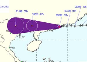
After a day of moving, Typhoon 3 (international name, Pabuk) fell to level 8. 7am this morning, the storm center in the sea between Hong Kong and Macau, about 80 km east of Macau. From tonight, the North will have rain due to the storm.
According to the Central Hydrometeorological Center, the day and night, the storm will move in the west with a fast speed of 20-25 km / h and weaken into a tropical depression. At 7 am tomorrow, the tropical depression is on the mainland of Guangxi Province (China).
When going deep into the mainland, tropical depressions continue to weaken into low areas. Forecast until 7 am on 11/8, lowland is located on the mainland border Vietnam - China (Lang Son province).

Predict the path and area of influence of storm No. 3. (Photo: NCHMF at 10 am this morning)
Influence of storms, north of the East Sea will have strong winds of level 6-7, near the storm center on level 8. The sea is very strong. From tonight, the North has rain, some places have heavy rain. People need to prevent flash floods and landslides.
According to the University of London TSR Station, the tropical depression yesterday in the Pacific Ocean became a storm, with the international name Wutip. This morning, Wutip approached Taiwan and will most likely land in this territory.
The Office of the Central Steering Committee for Flood and Storm Control urgently called provinces from Quang Ninh to Ha Tinh to urge the local authorities to announce the situation of the storm No. 3 for vehicles operating on the sea and guide them into the way of the room. avoid.
According to statistics, until 6 am this morning, Quang Ninh province has more than 360 ships with more than 2,000 people operating on the sea; Hai Phong city has nearly 220 ships with 870 people operating in Bach Long Vy area and Hai Phong coastal area. Thai Binh and Nam Dinh each province has more than 20 fishing boats near Hai Phong and Quang Ninh areas.
Functional forces are calling this ship into shelter.


The path of Typhoon Pabuk. (Photo: TSR)

The path of two storms Pabuk and Wutip. (Photo: TSR)
- Storm No. 6 is approaching the Vietnam-China border, the North is about to rain very hard
- Storm No. 6 weakened into a low pressure area, the North continued heavy rain
- East Sea welcomes storms, Bac Bo heavy rain
- Level 14 typhoon is about to affect the North
- Seventh storm weakened into low pressure, from the afternoon of August 28, Bac Bo had a large rain
- Storm No. 7: Mind the storm of level 16, heavy rain on a large scale
- Influence of typhoon Kalmaegi, from the north there is heavy rain
- Typhoon Wipha will cause heavy rain in the North
- Large-scale heavy rains in the North will likely last until July 22
- Storm No. 3 will land directly from Quang Ninh to Nam Dinh, Bac Bo with heavy rain
- Typhoon No. 4 weakened, the North and the North Central region had heavy heavy rain
- Storm No. 6 weakened, the North will have heavy rain
 Is the magnetic North Pole shift dangerous to humanity?
 Washington legalizes the recycling of human bodies into fertilizer
 Lightning stone - the mysterious guest
 Stunned by the mysterious sunset, strange appearance