Storm No. 7: Mind the storm of level 16, heavy rain on a large scale
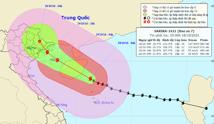
At 04:00 on October 18, the location of the center of the storm was about 18.4 degrees north latitude; 111.3 Kinh Dong, about 190km from Hoang Sa archipelago to the North-West. The strongest wind in the area near the center of strong storm level 14 (150-165km / hour), level 16 shock.
It is forecasted that in the next 24 hours, the storm will move west and northwest, about 15km per hour. At 04:00 on October 19, the location of the center of the storm is about 20.1 degrees North latitude; 108.3 degrees Kinh Dong, on the Gulf of Tonkin area, 60km from Bach Long Vi island to the West. The strongest wind in the area near the storm center is strong at level 12 (120-135km / hour), level 13-14.
In the next 24 hours , the area is dangerous (strong winds from level 6 or higher): in the North of the 16N line and in the West of line 114.5E). Strong wind zone from level 8 up: North of North 17N and West of the meridian 114.0E. Disaster risk level: level 3.

Direction of the storm No. 7.
The Gulf of Tonkin has strong winds of level 7-8, then increases to level 9-11, the area near the center of the storm is strong at level 11-12, level 13-14; Ocean waves 4-6m high, rough sea. Disaster risk level: level 3.
In the next 24 to 36 hours, the storm moved west-northwest, about 10km per hour. By 16:00 on October 19, the location of the center of the storm was about 20.8 degrees Vi Bac; 107.4 degrees Kinh Dong, on the coastal area of Quang Ninh-Hai Phong. The strongest wind is in the area near the storm center with strong level 9 (75-90km / hour), level 11-12 shock.
Due to the impact of storms, there are strong winds of 8-10 level in the Gulf of Tonkin, the area near the center of the storm passes through the level of 10-11, receding level 13-14; The waves are 3-5m high, the sea is very strong. Disaster risk level: level 3.
In the next 36 to 48 hours, the storm moved west-northwest, about 10km each hour, went to Quang Ninh-Hai Phong mainland and weakened into tropical depression. At 04:00 on October 20, the position of the tropical depression center is about 21.8 degrees Vi Bac; 106.7 degrees Kinh Dong, on Lang Son mainland. The strongest wind is in the area near the strong tropical depression at level 7 (50-60km / h), level 9-10.
Warning from the evening of this evening (October 18) to near the morning of October 20, there will be heavy rain on the areas of the North Eastern provinces, particularly Hai Phong, Quang Ninh and Lang Son: 200-300mm / whole time. .
- Influence of storm No. 7, Hanoi evening has heavy rain
- Large-scale heavy rains in the North will likely last until July 22
- Storm No. 7 is complicated, causing widespread rain
- Tornadoes make one dead, 80 injured
- Tropical depression on the South China Sea strengthened into a storm - storm Bebinca
- Storm Usagi approached Vung Tau, heavy rain
- Tonight, Bac Bo rains lightly, there is a place of heavy rain due to the effects of storms
- Seventh storm weakened into low pressure, from the afternoon of August 28, Bac Bo had a large rain
- Evacuate people to avoid storm No. 6
- Kai-Tak storm strengthened, Bac Bo heavy rain on the weekends
- Tin storm near shore, storm No. 4
- Hurricane number 9 with shock level 12 is 100km from Phu Quy island, the area of heavy rain is very affected
 Is the magnetic North Pole shift dangerous to humanity?
 Washington legalizes the recycling of human bodies into fertilizer
 Lightning stone - the mysterious guest
 Stunned by the mysterious sunset, strange appearance