Influence of storm No. 7, Hanoi evening has heavy rain
Due to the influence of the storm circulation No. 7, at 13:00 on October 18 at Bach Long Vi island station, it was able to measure strong level 8 wind, level 10 shock; Co To island, Cua Ong strong wind level 6, shock level 7, Mau Son (Lang Son) level 8.
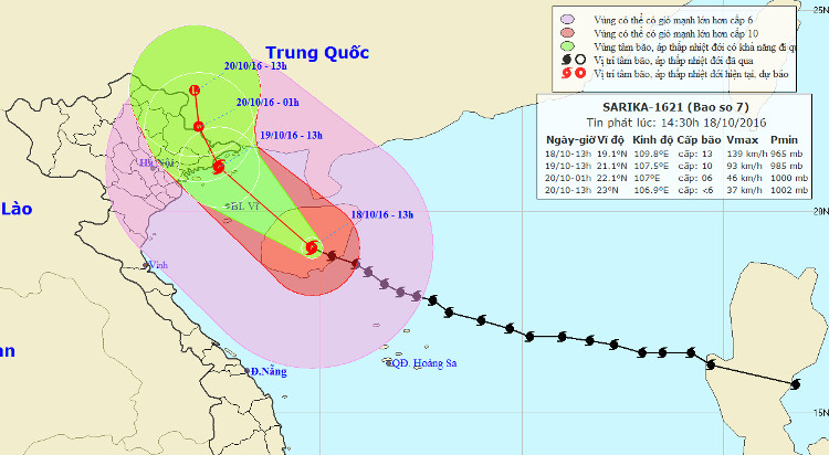
At 13:00 on October 18, the location of the center of the storm was about 19.1 degrees North latitude; 109.8 degrees Kinh Dong, on the mainland of Hainan Island (China), about 360km from Quang Ninh-Hai Phong to the Southeast. The strongest wind is in the area near the center of strong storm level 13 (135-150km / hour), level 16 jerks.
It is forecasted that in the next 24 hours , the storm will move in the Northwest direction, each hour is 15km. By 13:00 on October 19, the location of the center of the storm was about 21.1 degrees north latitude; 107.5 degrees Kinh Dong, on the coast of Quang Ninh-Hai Phong. The strongest wind is in the area near the center of the storm with level 10 (90-100km / hour), level 11-12.
In the next 24 hours , the area is dangerous (strong winds of level 6 or higher): North of the 170N and West of Meridian 1120E). Strong wind zone from level 8 or higher: North of the North 180N and West Kinh line 111.00E. Disaster risk level: level 3.

The path of Typhoon Sarika.
Due to the influence of typhoons in the South of Tonkin Gulf (the waters from Thanh Hoa to Quang Tri) there are strong winds of level 6-7; level 8-9 shock; strong sea. Northern Gulf of Tonkin (including the districts of Bach Long Vi, Co To, Van Don and Cat Hai) has strong winds up to level 8-10, the area near the center of the storm is strong at level 11-12, level 13-14; 3-5m high waves, rough seas. On the mainland, Quang Ninh, Hai Phong, Lang Son and Bac Giang provinces have strong winds of level 6-8, level 9-10; Particularly, Quang Ninh province in the North has strong winds of level 9-10, level 11-12. Disaster risk level: level 3.
In the next 24 to 36 hours , the storm has the ability to change the direction of north-northwest direction, about 10 to 15 km away every hour to the mainland and weaken into a tropical depression. At 01:00 on October 20, the position of the tropical depression center is about 22.1 degrees North latitude; 107.0 degrees east longitude, on land south of Guangxi province (China). The strongest wind in the area near the center of strong tropical depression at level 6 (40-50km / hour), level 7 shock.
Due to the impact of the following storm weakening into tropical depression, in the Northern Gulf of Tonkin (including the districts of Bach Long Vi, Co To, Van Don and Cat Hai), there are strong winds of 7-9, level 10 jams. 11; High sea waves of 2-4m, very strong sea. On the mainland, Quang Ninh, Hai Phong, Lang Son and Bac Giang provinces have strong winds of level 6-7, level 8-9; Particularly, Quang Ninh province in the North has strong winds of 9-10 level, shock level 11-12. Disaster risk level: level 3.
In the next 36 to 48 hours , the storm has the ability to change direction in the north, 10km per hour and weaken into a low pressure area on the mainland of Guangxi province.
Warning: from tonight (October 18) to the end of the night of October 19, there will be moderate rain and heavy rain on the areas of the North Eastern provinces, particularly Hai Phong, Quang Ninh and Lang Son: 200-300mm / whole batch
- Influence of No. 2 storm: Hanoi prolonged heavy rain, many streets were submerged in the sea
- Large-scale heavy rains in the North will likely last until July 22
- Seventh storm weakened into low pressure, from the afternoon of August 28, Bac Bo had a large rain
- Plants poured massively on Hanoi street
- Typhoon Nari landed in Danang, Central Vietnam with heavy rain
- Storm No. 5 will enter Hanoi at 15-16 this afternoon
- Tornadoes make one dead, 80 injured
- Tonight, Bac Bo rains lightly, there is a place of heavy rain due to the effects of storms
- Influence of typhoon Kalmaegi, from the north there is heavy rain
- This morning, the storm started to cause rain in the Central region
- Typhoon landfall in Quang Ninh - Nam Dinh, heavy rain up to 400mm, 4.0-4.5m rise
- 10 people died, 80 were injured in storms
 Is the magnetic North Pole shift dangerous to humanity?
 Washington legalizes the recycling of human bodies into fertilizer
 Lightning stone - the mysterious guest
 Stunned by the mysterious sunset, strange appearance