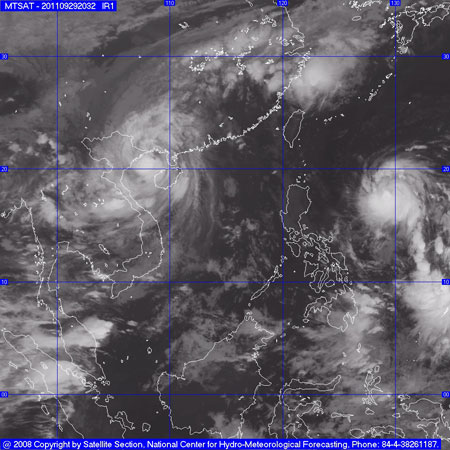
Storm No. 5 will enter Hanoi at 15-16 this afternoon
About 15-16h this afternoon, September 30, the storm No. 5 will enter Hanoi, the intensity of the storm may still be at level 7 and 8. "The capital has not had storms like this for decades .", Deputy The Standing Committee of the Steering Committee for Flood and Storm Control notices.
Mr. Le Thanh Hai - Deputy Director of the Center for Hydro-meteorological Forecasting said: 'At midday, September 30, the center of the storm No. 5 went into Quang Ninh and Hai Phong provinces and moved. low down to Thai Binh. At about 4pm this afternoon, the location of the storm in the South in the Northern Delta, then the intensity is at level 8, the coastal area is probably level 9 at level 10. About 4 am tomorrow morning, the storm No. 5 will go toward Western North and will weaken quickly '.

Image of cloud satellite number 5
Deputy Minister of Agriculture and Rural Development, Deputy Standing Committee of Steering Committee of Flood and Storm Control Dao Xuan Hoc noted the localities: Although there has not been significant damage, the localities are not subjective to neglect in storm prevention No. 5 Continue to strictly follow the guidance of the Government of the Government and the Steering Committee for Flood and Storm Control No. 5. At the same time, strengthen the forces of standing at critical points to ensure the safety of the dams, system of sea dikes and river dikes.
Steering Committee for Flood and Storm Control has issued a notice: About 15-16h this afternoon, storm No. 5 will enter Hanoi, storm intensity may still be at level 7 and 8. Therefore, units of storm prevention and control Hanoi needs to monitor and take the initiative in this situation. Because according to the forecast of the Central Hydrometeorology Center, the storm will go straight to Hanoi.
'The capital has not had a storm for decades like this, so I imagine it is complicated,' he said.
Meanwhile, according to the Central Hydrometeorology Center, due to the influence of storm circulation No. 5, on Co To island, there is strong wind 26m / s (level 10), shocking 38m / s (level 13); Bach Long Vi island has strong winds of 25m / s (level 10), shocking 33m / s (level 12); Cua Ong (Quang Ninh) has strong winds of 22m / s (level 9), shocking 38m / s (level 13); Phu Lien (Hai Phong) has strong winds of 15m / s (level 7); shocking 21m / s (level 9); Thai Binh has strong winds of 12m / s (level 6); jerk 19m / s (level 8).
In the northern provinces of Northern, North and Central Central, there is moderate rain, heavy rain, with a common rainfall of 20-50mm; some places have bigger rain like Co To 119mm; 97mm Mong Cai; Cua Ong (Quang Ninh) 114mm; Ba Don (Quang Binh) 103mm .
At 10 am this morning September 30, the location of the storm center is about 20.9 degrees North latitude; 107.3 Kinh Dong, on the coast of Quang Ninh - Hai Phong provinces. The strongest wind is in the area near the center of strong storm level 9, level 10 (ie from 75 to 102 km per hour), level 11 and level 12 jerks.
It is forecasted that in the next 12 hours, the storm will move in the direction of West and West Northwest, about 20km every hour, go into Quang Ninh - Hai Phong provinces and weaken into a low pressure area.
Due to the impact of storms in the Gulf of Tonkin today (September 30), there are strong winds of level 8, the area near the center of storms level 9, level 10, shock level 11, level 12. The sea is very strong. Coastal areas of provinces from Quang Ninh to Thai Binh have strong winds of level 6, level 7, storms near level 8, level 9, level 10, level 11; The northern provinces of the North have strong level 5 winds, some places are level 6, and shock level 7.
Coastal areas in the provinces from Quang Ninh to Nam Dinh need to watch for sea level rise combined with high tide from 2-4m. The Northern and Northern Central provinces have moderate rainfall and rain, particularly in the Northeast and Northern mountainous areas with heavy rains, where rain is very heavy. Preventing flash floods and landslides in mountainous areas, flooding in low-lying areas.
- Warning: Storm No. 2 intensifies, Hanoi rains heavily this afternoon
- Tin storm near the shore: Storm No. 3 appeared, heading to Da Nang - Quang Ngai
- Tonight strong Chebi storm level 15 will enter the South China Sea
- The North simultaneously welcomes storms and cold air
- Typhoon Mirinae faces the Northern Delta
- This afternoon, the tropical depression strengthened into a storm - the number 9 storm this year
- Hanoi shakes because of the quake 4
- This afternoon, super typhoon Mangkhut is more likely to enter the East Sea
- Hanoi put a lot of effort against storm Nesat
- Entering the capital of Hanoi, the storm weakened into a tropical depression
- Hanoi precludes thunderstorms, strong gusts of wind due to the impact of storm No. 1
- Mujigae storms move faster and stronger
 Is the magnetic North Pole shift dangerous to humanity?
 Washington legalizes the recycling of human bodies into fertilizer
 Lightning stone - the mysterious guest
 Stunned by the mysterious sunset, strange appearance