Tin storm near shore, storm No. 4
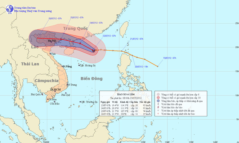
At 07:00 on July 23, the location of the center of the storm was about 19.4 degrees north latitude; 114.5 degrees Kinh Dong, 390 km from Hoang Sa archipelago to the Northeast. The strongest wind is in the area near the center of strong storm level 9, level 10 (ie from 75 to 102 km an hour), level 11 and level 12 jerks.
It is forecasted that in the next 24 hours, the storm will move in the direction between the Northwestern Northwest and the Northwest, about 10 to 15 km every hour and there is also a strong possibility. By 07:00 on July 24, the location of the storm center is about 20.8 degrees Vi Bac; 111.9 Kinh Dong, about 150km from Leizhou Peninsula (China) to the East. The strongest wind in the area near the storm center is strong at level 10 (ie from 89 to 102 km per hour), level 11 and level 12 jerks.

Beam photos of the location and path of the storm
In the next 24 to 48 hours, the storm moves mainly in the West-Northwest direction, about 15km per hour. At 07:00 on July 25, the location of the storm center is about 21.7 degrees Vi Bac; 107.9 Kinh Dong, on the coast of Quang Ninh province. The strongest wind in the area near the storm center is strong at level 8 (ie 62 to 74km per hour), level 9 and level 10 jerks.
In the next 48 to 72 hours, the storm moved mainly in the West, about 15km per hour.
Due to the impact of storms, in the North of the East Sea (including the northern sea of the Paracel Islands), there are strong winds of level 6, level 7, and the area near the center of the storm passes through level 9, level 10, level 11 shock. level 12 and showers and strong thunderstorms. The sea is very strong.
In addition, due to the strong influence of the southwest monsoon, the area between the South and the South China Sea (including the Spratlys waters), the waters from Binh Thuan to Ca Mau have strong winds of level 6, jerky. Sea level 7, level 8. Due to the influence of storm circulation, from tomorrow (24/7) in Bac Bo and Thanh Hoa, there will be moderate rain to heavy rain, where there is a big rain.
- Storm has not arrived, Danang has suffered
- Tin storm near the shore: Storm No. 3 appeared, heading to Da Nang - Quang Ngai
- Storm No. 3 will sweep through Hanoi, the closer it gets to the shore
- Why is the number 12 typhoon closer to the shore?
- Tin storm near shore (Storm No. 3) - update
- Tin storm near shore (Storm No. 3)
- Oil spreads to the shore, storms threaten stranded ships at sea
- Typhoon No. 3 approaching Quang Nam - Quang Ngai
- Tin latest storm No. 3: Lightning storms landed in Hai Phong - Ninh Binh
- Storm No. 15 has not melted, near the East Sea, a new storm appears
- Tropical depression strengthened into storm No. 2, heading to Quang Ninh - Hai Phong
- Storm Dianmu accelerated, Hanoi prepared to catch a storm
 Is the magnetic North Pole shift dangerous to humanity?
 Washington legalizes the recycling of human bodies into fertilizer
 Lightning stone - the mysterious guest
 Stunned by the mysterious sunset, strange appearance