Typhoon Wipha will cause heavy rain in the North
At 0:00 on August 1, Hurricane Wipha with winds of 90km / h is only 120km from the Gulf of Tonkin, forecast to cause heavy rain for the North East from this afternoon.
The National Center for Meteorological and Hydrological Forecasting said that the storm is in the west-northwest direction, the speed is 15km per hour and about 1/8 of the afternoon will enter the Gulf of Tonkin. At 22:00 on the same day, the storm center is about 150km east of the coast of Quang Ninh - Hai Phong, the strongest wind is 90 km / h, level 9, the shock is 2-3 levels.
Wipha then changed to the west, parallel to the coast of China, the slow speed was only 5-10 km per hour. At 22h on August 2, the storm center is on the coast of Quang Ninh, Hai Phong, the strongest wind is 90 km / h.
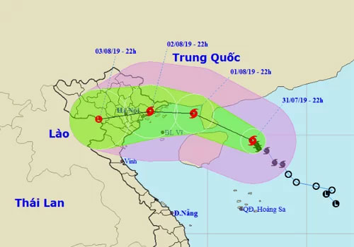
Predict the path and area affected by Wipha storm.(Photo: NCHMF).
After landing the coastal provinces from Quang Ninh to Nam Dinh, the storm went deep into the mainland and weakened into a tropical depression.
Mr. Hoang Phuc Lam, Deputy Director of the National Center for Meteorological and Hydrological Forecasting, said that the analysis and forecasts show that the highest possibility is that the storm surpassed Leizhou Peninsula (China), down to the Gulf of Tonkin. and landed in the northern provinces. However, it is still possible to storm along the border between Vietnam and China, or along the coast to the Northern Delta and Thanh Hoa.
"There are many scenarios of intensity and orbit, but it can be affirmed that Wipha storm will cause a heavy rain for the Northern provinces, part of North Central Vietnam," Lam said. Rain starts this afternoon in Eastern North Vietnam, then expands into the North at night, lasts until August 4 with the common rainfall of 100-300 mm / batch, particularly in Quang Ninh, Hai Phong and Lang provinces. Paint 200-400 mm / batch. The North Central region is affected so the rain is only 50-150 mm / batch.
Concentrated rain in a short time can cause flash floods, landslides in the northern mountainous provinces, especially the Northwest and the area along Hoang Lien Son range. In addition, heavy rains can cause flooding in urban depressions.
In the face of complicated developments of Typhoon Wipha, storm No. 3 this year, on the afternoon of July 31, the Central Steering Committee for Natural Disaster Prevention and Control sent electricity to the coastal provinces and cities from Quang Ninh to Da Nang. Northern region and ministries propose to review and tally ships and boats operating at sea to guide safe movement and shelter (including transport and tourism ships). Localities depend on specific situation to prohibit sea.
For coastal, delta and urban areas, cities and provinces should closely monitor changes in flooding, timely information to authorities and people to actively prevent, especially low-lying areas and mining areas. minerals, rivers, streams .
Formed from a low pressure area in the north of the East Sea on July 29, to July 30, it strengthened into a tropical depression and a day later became Wipha storm - the third storm to operate in the South China Sea in 2019.
In 2019, the East Sea is expected to occur around 9-11 storms and tropical depressions, of which 3-4 will directly affect the mainland of Vietnam.
- Tropical depression intensified into storm No. 3 - WIPHA storm
- Storm No. 3 will land directly from Quang Ninh to Nam Dinh, Bac Bo with heavy rain
- Plants fell mass in Hanoi and Hai Phong after the storm Wipha
- Typhoons in Quang Ninh cause flooding in Mong Cai, Hanoi and heavy rains threaten to flood many streets
- Typhoon No. 4 weakened, the North and the North Central region had heavy heavy rain
- Son Tinh storms weakened into low pressure, North Trung Bo was heavy rain
- Large-scale heavy rains in the North will likely last until July 22
- The North urgently resisted Typhoon Haiyan
- In the North, there is still a large area of rain, the Central Vietnam has ended the heat
- Storm No. 7: Mind the storm of level 16, heavy rain on a large scale
- From tomorrow night, the North rains heavily
- Big storm swept across Japan, 17 people died
- Tropical depression on the South China Sea strengthened into a storm - storm Bebinca
 Is the magnetic North Pole shift dangerous to humanity?
 Washington legalizes the recycling of human bodies into fertilizer
 Lightning stone - the mysterious guest
 Stunned by the mysterious sunset, strange appearance