Storm No. 4: Constantly calling for shelter boats
In the wake of the storm No. 4, on September 23, 2009, the Central Steering Committee for Flood and Storm Prevention and Control consecutively directed the localities to cope with the storm No. 4.
At 17h30, the Central Steering Committee for Flood and Storm Control continued to have the electricity sent to the Chairman of the People's Committees of Quang Ninh, Hai Phong, Thai Binh, Nam Dinh, Ninh Binh, Thanh Hoa, Nghe An and Ha Tinh provinces.
The Central Committee for Flood and Storm Control requires the Chairman of the People's Committees of provinces and cities to inform owners of boats and ships of the location and direction of the storm to find ways to prevent and avoid dangerous areas of storms. especially the area from 18 degrees north and above.
In addition to calling for ships and boats to safely shelter, the Central Steering Committee for Flood and Storm Control noted the provinces to arrange ships and boats at anchorage points, avoid breaking and sinking ships and have plans to protect protecting cages, rafts and coastal aquaculture areas. Prepare plans to evacuate people from dangerous areas when necessary. Note the islands, the critical sea dike area, the tourist area.
Early harvesting of rice and crops, preventing flooding, and reducing productivity. Actively drainage in the rice tea is not yet harvested. There is a plan to prevent flash floods in mountainous areas, protect existing works.

Storm No. 4 is approaching the mainland. (Photo: VNN)
The standing agencies for specialized search and rescue, the Steering Committee for Flood and Storm Prevention and Combat - Search and rescue the ministries, branches and localities maintain the forces and means to search and rescue as planned, ready to participate in rescue and handling situations. The online organization closely monitors all developments of the storm to deal with and deal with in a timely manner.
According to the forecast of the Central Center for Meteorological and Hydrological Forecasting, the storm No. 4 is likely to affect provinces in the Northern Delta and North Central in the next two days.
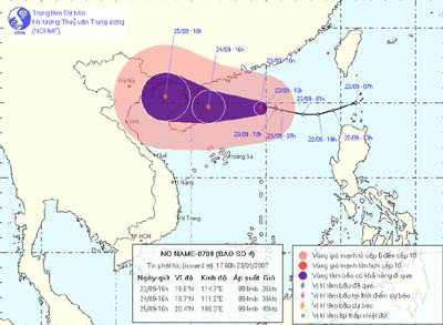
At 16h on September 23, the position of the center of storm No. 4 was about 19.6 degrees north latitude; 114.7 degrees east longitude, in the North Sea, about 420km east of Hainan Island (China).
The strongest winds in the area near the center of the storm are strong at level 8 (ie, 62 to 74 km per hour), jerking at level 8 and continuing to grow stronger.

(Photo: tsr.mssl.ucl.ac.uk)
It is forecasted that in the next 24 hours, the storm No. 4 moves mainly in the west, about 15km per hour. It is forecasted that in the next 48 hours, typhoon 4 will move in the direction of west-west and west-west, about 10 to 15km per hour.
At 16:00 on September 23, the location of the storm center is about 20.4 degrees north latitude; 108.3 degrees east longitude, about 70 km east of Bach Long Vi island to the northeast. From the center of the storm, the dangerous wind area from level 6 or higher has a radius of about 200km.
Thus, from the night of September 24, in the Gulf of Tonkin, the wind will gradually increase to level 6-7, then gradually increase to level 8, recoil on level 8. Strong sea level.
Due to the impact of storms, the north sea of the South China Sea, there are strong winds of level 8, recoil on level 8. Strong sea level. In addition, due to the combined effect with strong southwest monsoon winds, the waters from Binh Thuan to Ca Mau and the South China Sea area have strong winds of level 7, jerking at level 8. Strong sea level. During the storm, there was a strong whirlwind.
L.Hà (General)
- China hustled against storm Krosa
- 8 smart shelter houses
- Central: Many boats are in distress, stuck in the sea
- Typhoon into Quang Ninh: Power outages, shipwrecks, flooding
- Big storm struck the Philippines, 74 people were killed
- Storm has not arrived, Danang has suffered
- Central fishermen run away from storms
- House relief
- The secret of the bunker hidden over 300 rooms in the heart of Europe
- Inheritance of impenetrable nucleus underground
- Storm affected 50,000 boats and 80,000 people
- How did cargo ships survive the storm in the sea?
 Is the magnetic North Pole shift dangerous to humanity?
 Washington legalizes the recycling of human bodies into fertilizer
 Lightning stone - the mysterious guest
 Stunned by the mysterious sunset, strange appearance
 2024 Atlantic Hurricane Season Ends, Leaving Widespread Damage in Its wake
  Storm No. 9 Manyi, level 12, about 200km from Hoang Sa archipelago
  Video: Close-up of the terrible path of the Habood dust storm, causing 15 thousand people in the US to lose power
  Typhoon Tra Mi forms in the East of the Philippines, likely to strengthen into a hurricane when entering the East Sea
  Storm Trami will reach its maximum intensity when it approaches the Paracel Islands.
  Storm Tra Mi enters the East Sea today, strange movement direction