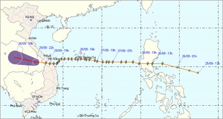
Storm No. 9 has weakened into a tropical depression
On the night of September 29, typhoon 9 passed through Quang Nam province and quickly weakened into a tropical depression and then moved to Laos. However, the current flood after the storm is threatening the Central people.
With the gust of wind to 14-15 level in the sea, noon 9/9 storms quickly flooded the provinces from Quang Nam - Da Nang. However, wind power has decreased to level 8 level 9 jerk level 10.
According to the latest news from the Center for Hydro-meteorological Forecasting: At 22h on September 29, the position of tropical depression is about 15.6 degrees North latitude; 106.5 degrees east longitude in southern Laos. The strongest wind in the area near the low pressure center drops to level 6, level 7, level 8 jerks
In the next 12 hours, this tropical depression went deep into the mainland and weakened into a low pressure area and continued moving to the Northeastern region of Thailand, the wind continued to decrease.
Due to the influence of the circulation of the tropical low pressure area, today September 30 in the North Central, Central and Central Highlands provinces, there is continued rain to heavy rain, where rain is very heavy. Thus, the central provinces after storms must respond to floods.

Storm No. 9 weakened into a tropical depression and moved to southern Laos.
Meanwhile, the impact of typhoon No. 9, on the 28th and 29th of September (as of 19h of September 29) in Quang Binh, Binh Dinh and Tay Nguyen provinces, has heavy rains, popular water levels. measured from 100-150mm, Quang Tri and Kon Tum provinces are popular with 200-300mm, Thua Thien Hue and Quang Nam Da Nang provinces are popular with 300-500mm, some places over 600mm like Nam Dong are 857mm, Tra Bong 899 mm, Quang Ngai is 672 mm .
Also according to an urgent report from the Center for Hydrometeorological Forecasting, flooding rivers from southern Quang Binh to Phu Yen, Gia Lai, Kon Tum and Dak Lak are rising very fast. In the early morning of September 30, floods in the rivers from Thua Thien Hue to Quang Ngai will be above alarm level 3; In the rivers of Gia Lai and Kon Tum, flood levels can exceed the history from 1 - 3.5m.

Rain storm in Da Nang.(Photo: Tra Bang)
Meteorological agencies warned about flash floods and landslides in mountainous areas, extensive flooding in the delta, low-lying areas along the rivers of Quang Binh to Phu Yen and Gia Lai provinces of Kon Tum and Dak Lak.
Immediately after the storm passed, Deputy Prime Minister Hoang Trung Hai instructed localities to quickly rescue people from flooded areas, flooded on the night of September 29.
The Deputy Prime Minister asked Military Region 4 and 5 to strengthen the rescue force for the people, especially in Kon Tum, although the roads were divided and had to find all remedies.In addition, the provinces have to provide relief for food and clean water for people in flooded areas, divided areas, absolutely do not let people suffer from hunger during and after floods.
The Ministry of Industry and Trade directed the Electricity Group to overcome the problem in Quang Ngai right on the night of September 29 so that on September 30, the Dung Quat factory will be put into operation again.
- Typhoon Tembin weakened into a tropical depression
- Storm No. 1 weakened into tropical depression, the North continued to have small rain
- Washi weakened into a tropical depression
- Storm No. 14 weakens into a tropical depression
- Tropical depression Kajiki weakened in the East Sea
- Typhoon Khanun weakened into a tropical depression
- Storm No. 13 weakens into a tropical depression
- Matmo storm weakened into a tropical depression
- Banyan storm weakened and suddenly
- Tropical depressions melted, the flood in the Central region increased quickly
- Storm No. 6 weakened, heavy rain in Thanh Hoa - Quang Nam
- Strong tropical depression into storm No. 1, approaching the Vietnamese mainland
 Is the magnetic North Pole shift dangerous to humanity?
 Washington legalizes the recycling of human bodies into fertilizer
 Lightning stone - the mysterious guest
 Stunned by the mysterious sunset, strange appearance