A study by the University of Colorado at Boulder said most of the low-river deltas are subsiding due to human impact. Therefore, the delta area is more vulnerable to flooding from rivers and storms. The lives of tens of millions of people are at stake.
In 2007, a report by the Intergovernmental Panel on Climate Change came to the conclusion that many delta regions are threatened by rising sea levels. This new study shows that human-related factors are causing this condition to worsen. The researchers concluded that subsidence in the river delta from Asia and India to the Americas is worse because the sediment in the upstream has been swept into the sea by lakes, dams, artificial channels and dykes.
This study concludes that 24 of the world's 33 largest delta regions are subsiding. 85% of these people have suffered severe flooding in recent years, leaving behind the consequences that about 100,000 miles of land were submerged. It is estimated that about 500 million people live in river delta regions around the world.
The results of the study were published on September 20, 2009 in Nature Geoscience. Running this research program is Professor James Syvitski. He took on the responsibility of using US $ 4.2 million funded by the US National Science Foundation to model global processes on a wide scale such as erosion and flooding. Known as the Surface Dynamics Modeling System (CSDMS), this effort attracted the participation of hundreds of scientists from federal laboratories and universities across the United States.
The authors of the study refer to the forecast of the Intergovernmental Panel on Climate Change in 2007. Accordingly, floods in the river delta will increase by 50% along with sea level rise by 18 inches at the end century . Floods will be even more if the sediment due to lakes in the upstream delta and river diversion projects continue to deploy, preventing the expansion of the delta.
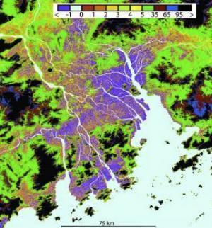
 According to a study by the University of Colorado - Boulder, the delta regions around the world are subsiding. This image was taken by NASA's Endeavor space shuttle in the Pearl River Delta region, China. Purple indicates the area below the sea level. (Photo: NASA, University of Colorado)
Albert Kettner, co-author of this study at the Arctic Research Institute and the Alps, University of Colorado, member of the CSDMS team said: 'We think that the delta areas of the rivers are getting lower and lower. vulnerable to flooding from rivers or storms. Research shows that many factors related to people - not just rising sea levels - have caused the situation of subsidence in the delta region to happen faster. '
Other authors participating in this study include Irina Overeem, Eric Hutton, Mark Hannon from Colorado University, G. Robert Brakenridge - Dartmouth College, John Day - Louisiana University, Charles Vorosmarty - New York University, Yoshiki Saito - Japan Geological Survey, Liviu Giosan - Institute of Oceanography and Robert Nichols - University of Southampton - England.
The team used satellite data from NASA shuttle spacecraft.The Endeavor spacecraft brought along radar equipment, scanning over 80% of the earth's surface for a 12-day mission in 2000 . The researchers compared these data with maps published between 1760 and 1922.
Overeem, from the University of Colorado, is also a researcher of INSTAAR and CSDMS said: 'Every year, about 10 million people are affected by storms. Hurricane Katrina in the US is probably the best example. However, in Asia, floods in the Irrawaddy River Delta - Myanmar and the Brahmaputra Ganges in India and Bangladesh also cost thousands of people. '
The researchers also warned that similar disasters could occur in Pearl River Delta, China and the Mekong Delta in Vietnam. Thousands of miles in these two areas are below sea level and still suffer from cyclical storms every year.
The authors of the study said: 'Although humans have captured the daily activities of rivers in low-lying areas, we still cannot cope with storms with rising sea levels. 3 to 10 meters tall. There are still warnings about the flooding density in the delta, whether flood comes from land or from the sea. And this trend seems to be getting worse. '
Syvitski, a professor of geoscience at the University of Colorado, said: 'We are very interested in learning how the land and sea have changed over time and how matter like water , sediments and nutrients were transported from one place to another. CSDMS's effort will bring a deeper understanding of the earth and allow us to more accurately predict the areas at risk of being threatened by deforestation, forest fires, changing land use and consequences of climate change. '
 Is the magnetic North Pole shift dangerous to humanity?
 Washington legalizes the recycling of human bodies into fertilizer
 Lightning stone - the mysterious guest
 Stunned by the mysterious sunset, strange appearance