Super flood split England from Europe
Scientists identified the process of thin strips of land connecting ancient England with Europe destroyed in a massive flood that occurred nearly half a million years ago.
The research team at Imperial College London discovered special traces at the bottom of the English Channel, showing a massive flood hundreds of millions of years ago that destroyed the strip of land connecting Britain and Europe, creating a waist. Dover sea today, according to the BBC.
"This is one of the important events that shape the north-west of France and even the history of England. If this accidental geological event does not happen, Britain will be associated with the continent of Europe." Professor Sanjeev Gupta, writing in a study published April 5 in Nature Communications.
More than half a million years ago, in the middle of the Ice Age, a strip of land connecting Dover in southern England with Calais in northern France. In the north of the strip is a giant glacial lake, formed at the edge of the ice shelf that covers the European part. The team believed that when the lake began to overflow, a large amount of water was massively flowing through the strip.
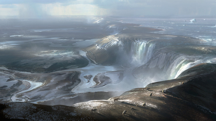
The strip of land connecting the UK and Europe in the Ice Age.(Photo: Royal University of London).
Decades ago, engineers surveying the bottom of the Channel for a Tunnel Tunnel tunnel project discovered a series of mysterious large holes at the bottom of the sea. The results of the research showed that they are more likely to be the result of overflowing lake water.
"These holes are now full of sediment, but the interesting thing is that they don't have related traits like alleyways or valleys. They are isolated concave areas. The holes extend into a track between Dover and Calais. They are huge in size, eating 100 meters deep into the bedrock with a diameter of several hundred meters to several kilometers, " Professor Gupta said.
"We think these are very deep pools. Basically, the lake water is deep through the rock at the Dover Strait through a series of waterfalls, then eroding and cutting into the depression. This terrain is difficult to solve. like any other mechanism, ' explained Professor Gupta.
According to the research team, the lake began to overflow about 450,000 years ago, severely weakening the land. The second disaster event was a flood that occurred 150,000 years ago that completely destroyed the strip of land."We found the valley below the strait, about 8-10 km wide, with many features that are traces of the erosion caused by flooding , " Professor Gupta said.
Scientists have not yet determined the cause of the two events mentioned above."Maybe a part of the ice shelf collapsed, collapsed into the lake, leading to the lake water being spilled out, and creating a pathway of water flowing down the strip. The breakage of the strip could be due to underground vibration. , followed by a super flood, " Jenny Collier of the Royal College of London, co-author of the study, speculated.
The researchers plan to find the exact timeline of the event by drilling at the bottom of Dover Strait and analyzing the age of sediment, although this task is difficult to do due to the density of boats passing through the Channel. along with strong tides.
- The Great Pink turned England into an island
- Thousands of German and Hungarian people evacuated because of record high floods
- Do people with brains split apart, are their souls divided into two different halves?
- Central Europe is miserable because of the worst flood in the last decade
- Super flood marks stretch over 3,000km on Mars
- Video: European zoo animals are bewildered by the flood
- Super moon and solar eclipse also appear in England
- The sky is like a split in twilight in Canada
- The harshness of the weather in 2013
- Bird flu attacks Western Europe
- Why do a series of super storms suddenly appear around the world?
- The meteorological term makes Trump misunderstand about super typhoon Harvey
 Is the magnetic North Pole shift dangerous to humanity?
 Washington legalizes the recycling of human bodies into fertilizer
 Lightning stone - the mysterious guest
 Stunned by the mysterious sunset, strange appearance