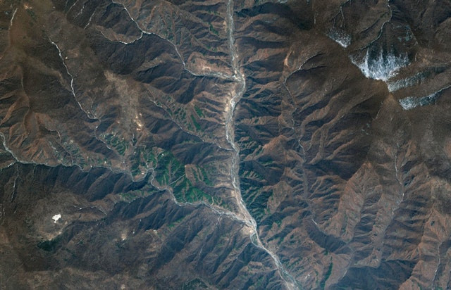
The Korean mountain moved more than three meters due to a nuclear test
Satellite image shows Mantap Mountain, where North Korea conducted a nuclear bomb test, moved about 3.5 meters due to the impact of the explosion.
Korea conducted the latest nuclear test at Punggye-ri test site on September 3 , 2017 and this is the biggest test ever, creating a 6.3-degree earthquake-equivalent vibration recorded from sensor, Live Science reported. About 8 minutes after the test, geologists discovered that vibration was smaller than 4.1 degrees, leading to speculation that the nuclear test site inside the mountain had collapsed.
The collapse could make the test site no longer suitable for future nuclear tests, even increasing the risk of radioactive dust escaping from the rock and spreading in the air. The possibility of this phenomenon of "fatigue mountain syndrome" was even higher when three weeks ago, North Korea announced its plan to close the main test facility in Mount Mantap , where five of the six cases took place. to try on. In the study published in the journal Geophysical Research Letters, a group of Chinese geologists, insisted that the mountain collapsed after the latest nuclear test.

Punggye-ri nuclear test site in satellite images.(Photo: DigitalGlobe).
In a report published yesterday in Science magazine, scientists using satellite images and Mantap mountain detection have actually moved and are compressed after the explosion. But according to the research team, the mountain and the testing ground may not have completely collapsed.
Previously, researchers measured nuclear explosions through earthquake vibrations caused by explosions, using seismic data similar to earthquake measurements. But in the new study, the international team of scientists analyzed satellite images captured by the German TerraSar-X and Japan's ALOS-2, and compared the scenery of the Mantap mountain before and after the explosion. These satellites use synthetic aperture radars, transmit electromagnetic waves to Earth and measure reflected light later, according to the US National and Atmospheric Administration (NOAA). The technology can produce high resolution images even in bad weather conditions and poor light due to microwaves that can penetrate clouds.
Through satellite images, the team calculated Mantap mountain moving about 3.5 meters and shrinking 0.5 meters. This reveals the collapse of the mountain inner tunnel, according to Teng Wang, a senior graduate student at Singapore's Earth Observatory at Nanyang Technological University."But we cannot conclude whether both the test site and the tunnel have completely collapsed because there is no direct evidence to prove it," said Wang, the study's lead author.
Ground vibration can result from the collapse of a void in the rock created by the previous explosion or the nearest explosion, according to Douglas Dreger, professor of Earth and Planet science at the University. California, Berkeley, co-author of the study. Wang and Dreger's group estimated the strength of the explosion at about 120-130 kiloton, 10 times the atomic bomb dropped on Hiroshima.
- Suspected that the crust shifted after the Korean nuclear test
- Learn about the Korean 'national dog' variety
- The mountain of North Korea tried thermonuclear bombs to explode
- Earthquakes occurred near the Korean nuclear test site
- Rare photos of Korea before being divided into two countries
- The United States announced hundreds of videos of top secret nuclear bombs
- Curiosity robot has moved to the foot of Sharp mountain
- Japan moved 4 meters, the earth turned faster
- The risk of 'nuclear coffin' on the ocean leaks disaster
- Koreans got strange diseases after missile tests
- The most atomic bombing place on the planet: 10,000 years of danger!
- Ikata nuclear plant passes an earthquake test
 Is the magnetic North Pole shift dangerous to humanity?
 Washington legalizes the recycling of human bodies into fertilizer
 Lightning stone - the mysterious guest
 Stunned by the mysterious sunset, strange appearance
 Chinese hypersonic aircraft prototype reaches Mach 6 speed
  Revealing the secret of 'not eating anything before taking blood' and what happens if we 'accidentally eat'
  Solution using balloons to pull spacecraft up to 30,000m
  America invented a test that can detect 50 forms of cancer
  New technology helps to quickly diagnose dengue fever
  Belgian researchers develop device for analyzing water quality using... paper