The oldest Western map
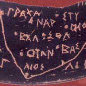
Scientists have found a piece of earthenware as black as a stamp, depicting the Italian heel. It is called the Soleto map and dates back to 500 BC.
 The map depicting the Saletine Peninsula in Puglia was found two years ago during an excavation led by Belgian archaeologist Thierry van Compernolle. However, the findings are kept secret so researchers can confirm it is real. " This is the oldest geographic map ever discovered ," Compernolle said.
Displayed for the first time last weekend at the National Archaeological Museum in Taranto, Italy, the broken pottery was engraved in Greek and a local language called Messapia.
" The map is unique in many places. It depicts the coastline creating a very recognizable space: the southern tip of the Salentine Peninsula, in ancient times called Iapygia, " Mario Lombardo, professor of history at Dai Study Lecce, explain.
The Ionian Sea and Adriatic on the other side of the peninsula are described by parallel zig zag lines. In the West is the recognizable Greek country written in Taras name.
In total, the map depicts 13 towns, marked with dots, just like on the map today. Many in those towns, like Otranto, Soleto, Ugento, Tarnto and Leuca, still exist today.
The Lombardo researcher believes that there is more than one hand that makes this map. " We can distinguish between places written in lower and lowercase, while others are written in geographic and heterogeneous symbols ," Lombardo said.
According to scholar Antonietta Dell'Aglio, map Soleto validates the important relationship between Messapia tribes and Greek culture.
MT
- 14 oldest ancient artifacts in the world
- 10 oldest antiquities in the world
- Found the oldest fossil on Earth
- The oldest man in the world died, aged 112 years
- New discovery of the origin of the world's oldest wine
- The 10 most original and ancient artifacts of humanity
- Discover the most ancient document about the Odyssey
- Footprints emigrated to North America from 13,200 years ago
- Displaying the oldest western map is drawn on papyrus
- Discover the oldest DNA man in North America
- Red swirl in the sky of Western Australia
- Not Everest, this is the oldest mountain on Earth
 Discovered an ancient centipede fossil 99 million years old
 Discovered bat-like dinosaurs in China
 Discovered a 200-year-old bronze cannon of the coast
 Discover 305 million-year-old spider fossils