The terrible flood cooled the earth
Geologists say they have learned how a vast lake under the ice that once covered most of North America could draw to the sea, an event that has cooled the earth for hundreds of years.
When the temperature of the earth warmed up about 10,000 years ago, the ice withdrew leaving a gap in the Great Lakes region today. Under the thin ice formed a giant mass of water - the Agassiz-Ojibway ice lake. The country is so large that it covers many parts of Manitoba, Saskatchewan, North Dakota, Ontario and Minnesota. Then, about 8,200 years ago, the Agassiz-Ojibway glacier was drained and freed a huge stream of water into the Hudson Strait and Labrador Sea, 15 times larger than the flow of the Amazon River. As a result, the sea level rises to 14m.
How this terrible flood is liberated is still a controversial issue. Some experts believe that a ice dam breaks or water flows out of the ice.
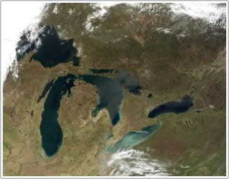
Photographs provided by NASA on May 20, 2002 show all of the Great Lakes in America.Geologists say they have learned how a vast lake under the ice that once covered most of North America could draw to the sea, an event that has cooled the earth for hundreds of years.(Photo: AFP)
Two researchers Lajeunesse and Guillaume Saint-Onge in Quebec argue that the eruption occurs under the surface of the ice rather than on or through. In a paper appearing in the journal Nature Geoscience , the two scientists describe how they studied cross Hudson Bay on a research vessel, using an ultrasonic underwater navigation system to scan the area. stretching to 10,500 km and obtaining the bottom image of the bay.
In the south of the bay, they discovered deep waves in the sandy carpet that stretched over 900km and about 1.7m deep. There are signs that the bottom layer, once protected by a strong ice, is swept by a very strong flow many years ago, but it still exists today.
In the west, they found strange signs of parabola twisting up to the northeast. The arc lines are about 3 meters deep on the seabed surface at a depth of about 80 to 205m.
They believe that the bay's ice sheets were swept away by the giant flood.
The jagged top of the iceberg was trapped in the seabed and acted as a rotating cylinder. Other evidence includes many deep underground channels and red sediments extending from the western mainland of Hudson Bay across the northwestern floor - a sign that a current has swept this area before.'The ice was lifted up quite sharply, allowing the flood to sweep south of Hudson Bay under the ice surface.'
Previous works have suggested that the flood is so big that it affects the climate all over the world.
The overflow of freshwater in the North Atlantic reduces ocean salinity so much that it inhibits the process of heat circulation from tropical to temperate regions. Temperatures in western Europe fell by more than 3 ° C for about 200-400 years, a small Ice Age in this region.
- What is left after the terrible mud flood over
- 10 terrible disasters in human history
- The sun is dangerously cooling down?
- View from the perspective of climate change
- Explore the flood protection system of treasure walls in the world's No. 1 country
- Self-cooled roofing materials
- The North is about to have a new flood
- The world's longest automatic flood protection system
- The process of formation and evolution of life on Earth
- Russia: Floods forced tens of thousands of people to evacuate
- 27 people died in the central flood
- Australia mobilizes troops to participate in flood fighting
 Surprised: Fish that live in the dark ocean still see colors
 Japan suddenly caught the creature that caused the earthquake in the legend
 A series of gray whale carcasses washed ashore on California's coast
 Compare the size of shark species in the world