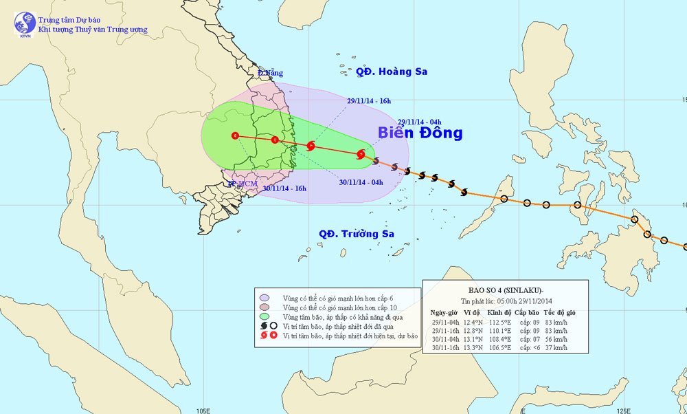
Typhoon 4 advanced quickly to the mainland
At 04:00 on November 29, the location of the storm center is about 12.4 degrees north latitude; 112.5 degrees east longitude, about 350 km from Phu Yen - Khanh Hoa coast to the East. The strongest winds in the area near the storm center are strong at level 9 (ie from 75 to 88km an hour), level 10 and level 11 jerks.
>>>Tropical depression intensifies into a storm
It is forecasted that in the next 12 hours , the storm will move in the West-Northwest direction, about 20 - 25km per hour. By 16:00 on November 29, the location of the center of the storm was about 12.8 degrees Vi Bac; 110.1 degrees Kinh Dong, in the waters of Binh Dinh - Khanh Hoa provinces. The strongest winds in the area near the storm center are strong at level 9 (ie from 75 to 88km an hour), level 10 and level 11 jerks.
Due to the impact of storms, the area in the northwest of Truong Sa archipelago this morning (November 29), there are strong winds of level 6-7, the area near the center of storms is 8-9, level 10 - 11. 3-5m. Sea level is very strong (level 3 disaster risk level). From this afternoon (November 29), the waters of the provinces from Quang Nam to Ninh Thuan have strong winds of level 6-7, the area near the center of storms is about 8-9, level 10 - 11. The sea waves are from 2 - 4m high. Sea level is very strong (level 3 disaster risk level).

Photo of the path and location of the storm No. 4
It is forecasted that in the next 12 to 24 hours , the storm will move in the West-Northwest direction, about 20km every hour, going into the mainland of the southern central coastal provinces and gradually weakening into a tropical depression. At 04:00 on November 30, the position of the tropical depression center is about 13.1 degrees North latitude; 108.4 degrees Kinh Dong, on the mainland of the South Central and Central Highlands provinces. The strongest wind in the area near the center of strong tropical depression at level 6 (ie from 39 to 49km per hour), shock level 7-8.
Due to the impact of storms, coastal areas from Quang Ngai to Khanh Hoa provinces from this afternoon (November 29), there are strong winds of level 6-7, the area near the center of the storm passes through level 8, shock level 9-10 (level Level 3 disaster risks, in Gia Lai - Dak Lak provinces with level 5 strong winds, places at level 6, level 7. The provinces from Da Nang to Binh Thuan and the Central Highlands from this afternoon (29 / 11) moderate rain, very heavy rain.
Forecast for the next 24 to 36 hours , tropical depressions continue to move in the direction of West-Northwest, about 15km every hour and weaken into a low pressure area on the land area of Cambodia.
In addition, from mid-afternoon and night of November 30, there will be a strong northeast monsoon that affects the North, then Central.
- Typhoon Sarika will land in Vietnam
- Hurricane No. 3 moves quickly, landing in provinces from Thai Binh to Ha Tinh
- Hurricane number 11 advanced quickly into the South China Sea
- Typhoon Soudelor landed in mainland China, causing flash floods that killed at least eight people
- Super storms appear near the East Sea
- Storm No. 1 enters the mainland and weakens into a low pressure
- Philippines prepares to receive super typhoon
- Son Tinh storms weakened into low pressure, North Trung Bo was heavy rain
- Quang Ninh suddenly interested in Typhoon Haiyan
- Hurricane Kalmaegi went deep into the land and reduced levels
- Mangkhut super typhoon weakened into tropical depression on mainland China
- Tonight the storm landed Hai Phong, Thai Binh and Quang Ninh
 Is the magnetic North Pole shift dangerous to humanity?
 Washington legalizes the recycling of human bodies into fertilizer
 Lightning stone - the mysterious guest
 Stunned by the mysterious sunset, strange appearance