Typhoon Man-Yi will attack Taiwan, Japan and China?
On the morning of July 9, storm 4W was officially named Man-Yi, registered by Hong Kong (China). This is the name of a strait, which has become a natural lake today. Tropical Storm Center TSR (UK) has officially issued a warning to Taiwan, Japan and China.
Some provinces of two countries and one territory will experience strong winds in the next 120 hours. The US military's JTWC warning network based in Hawaii also issued warning number 5 about the storm. Accordingly, on the morning of July 9, the storm reached nearly 9.5 degrees north, 143.7 degrees east, 310 miles south of Guam and 16 feet high, and 45 to 55 knots. The storm is going northwest and maintaining this road for the next few days at a speed of 10 knots or more.
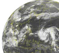
Satellite image of storm region 4W in operation (Photo: NPMOC, TN)
Forecast, until 19h on 10/07, the center of the storm is nearly 13.8 degrees north 138.7 degrees east, maximum winds 80 to 100 knots / h. Typhoon continues northwest, 13 knots / h. The JTWC's long-distance forecast said that by 19:00 on July 12, the storm was directed to 19.8 degrees north, 129.7 degrees east, stormy winds increased to 115 to 140 knots. Then one day, the center of the storm reached nearly 24.5 degrees north of 125.7 degrees east, maximum winds of 125 knots / h, recoiled 150 nautical miles / h. At this time, the storm began to affect Taiwan and Okinawa.
However, according to JTWC, the path of the storm is often complicated, so the long-range forecast may be inaccurate, 250 miles to 350 miles from the 4th to 5th forecast. Thus, no exclusion, Typhoon Man-Yi, instead of landing on Taiwan, Shanghai (China) and Okinawa (Japan) as the current forecast, may change the direction of Vietnam landing like Typhoon Toraji (No. 1) just now, despite the possibility This proved uncertain.
Based on the current speed of the storm, Typhoon2000 believes that Typhoon Man-Yi will enter the Philippine Sea (PAR) on July 11. The network also predicts that the northwest monsoon will impact strongly on the Philippines from July 12 to 14. Due to the storm, the monsoon system will increase in the west of Luzon and Visayas islands, including Metro Manila. However, there is also good news, turbulent wind mass (90W / LPA / 1008 MB) recorded by Typhoon2000 on July 7 in the East Sea has been dispelled due to unfavorable regional environment.
Dang Ngoc Khoa
- Horror image of the strongest storm of the year seen from the universe
- Adding super typhoon 240km / hour winds to Japan and Taiwan
- Typhoon raging Japan
- Typhoon Soudelor entered Taiwan, the South China Sea has strong winds
- Super typhoon Dujuan landed in Taiwan, thousands of people evacuated
- The typhoon Nanmadol indirectly caused the male to rain a lot
- 400 people disappeared due to typhoons in Taiwan
- Super storm Meranti landed, Taiwan was deserted
- Intense earthquakes in Japan and Taiwan
- Taiwan evacuated 6,000 people before typhoon Parma
- The most powerful super typhoon in the year goes straight to Japan and China
- Severe typhoon level 16 is about to enter the South China Sea
 Is the magnetic North Pole shift dangerous to humanity?
 Washington legalizes the recycling of human bodies into fertilizer
 Lightning stone - the mysterious guest
 Stunned by the mysterious sunset, strange appearance